| Colnbrook | |
|---|---|
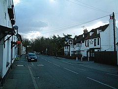
 High Street, Colnbrook | |
Location within Berkshire | |
| Population | 6,157 |
| OS grid reference | SU945805 |
| Civil parish | |
| Unitary authority | |
| Ceremonial county | |
| Region | |
| Country | England |
| Sovereign state | United Kingdom |
| Post town | SLOUGH |
| Postcode district | SL3 |
| Dialling code | 01753 |
| Police | Thames Valley |
| Fire | Royal Berkshire |
| Ambulance | South Central |
| UK Parliament | |
Colnbrook is a village in the Slough district in Berkshire, England. It lies within the historic boundaries of Buckinghamshire, and straddles two distributaries of the Colne, the Colne Brook and Wraysbury River. These two streams have their confluence just to the southeast of the village. Colnbrook is centred 3 miles (4.8 km) southeast of the Slough town centre, 4 miles (6.4 km) east of Windsor, and 19 miles (31 km) west of central London.
Colnbrook forms the greater part of the civil parish of Colnbrook with Poyle (see also Poyle). Junctions of the M4 and M25 are near the village. To the east is Longford, London, and Bedfont and Stanwell which abut the south of London Heathrow Airport.
Colnbrook with Poyle is a suburban parish with significant industrial units, logistical premises and open land. The parish was created on 1 April 1995 as an amalgamation of Colnbrook from Iver to the north and the smaller Poyle from an unparished area of Stanwell to the south-east. At the 2011 census the whole civil parish had a population of 6,157 living in 2,533 homes.[1]
- ^ "2011 Census". Archived from the original on 11 February 2003. Retrieved 17 August 2013.
