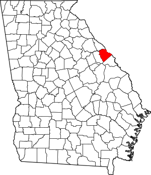
Columbia County | |
|---|---|
 Columbia County Courthouse in Appling | |
 Location within the U.S. state of Georgia | |
 Georgia's location within the U.S. | |
| Coordinates: 33°33′N 82°16′W / 33.55°N 82.26°W | |
| Country | |
| State | |
| Founded | 1790 |
| Named for | Christopher Columbus |
| Seat | Appling (de jure) Evans (de facto)[1] |
| Largest community | Martinez |
| Area | |
• Total | 308 sq mi (800 km2) |
| • Land | 290 sq mi (800 km2) |
| • Water | 18 sq mi (50 km2) 5.7% |
| Population (2020) | |
• Total | 156,010 |
| • Density | 538/sq mi (208/km2) |
| Time zone | UTC−5 (Eastern) |
| • Summer (DST) | UTC−4 (EDT) |
| Congressional district | 12th |
| Website | www |
Columbia County is a county located in the east central portion of the U.S. state of Georgia. As of the 2020 census, the population was 156,010.[2] The legal county seat is Appling,[3] but the de facto seat of county government is Evans.[1]
Columbia County is included in the Augusta-Richmond County, GA-SC metropolitan statistical area. It is located along the Savannah River.
- ^ a b Columbia Court House Archived February 21, 2008, at the Wayback Machine at Carl Vinson Institute of Government, University of Georgia, website. Accessed February 15, 2008.
- ^ "Census - Geography Profile: Columbia County, Georgia". United States Census Bureau. Retrieved December 26, 2022.
- ^ "Find a County". National Association of Counties. Archived from the original on May 31, 2011. Retrieved June 7, 2011.
