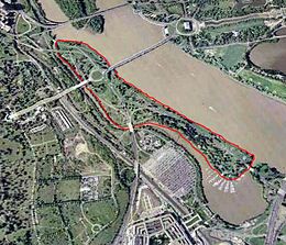
 Aerial view of Lady Bird Johnson Park (outlined in red) | |
 | |
| Geography | |
|---|---|
| Location | Potomac River, Washington, D.C., U.S. |
| Coordinates | 38°52′56″N 77°03′26″W / 38.8823342°N 77.0571996°W |
| Total islands | 1 |
| Area | 0.19 sq mi (0.49 km2) |
| Length | 1.32 mi (2.12 km) |
| Coastline | 2.95 mi (4.75 km) |
| Highest elevation | 22 ft (6.7 m) |
| Administration | |
United States | |
| Demographics | |
| Population | 0 |
Lady Bird Johnson Park, formerly known as Columbia Island until 1968, is an island located in the Potomac River in Washington, D.C., in the United States. It formed naturally as an extension of Analostan Island in the latter part of the 1800s, and over time erosion and flooding severed it from Analostan, now known as Theodore Roosevelt Island.
The U.S. federal government deposited material dredged from the Potomac River on the island between 1911 and 1922, and again from 1925 to 1927. The island was also reshaped by the government at this time "to serve as the western terminus of Arlington Memorial Bridge and a symbolic entrance into the nation’s capital."[1] Located within the park are the Lyndon Baines Johnson Memorial Grove, Navy – Merchant Marine Memorial, and the Columbia Island Marina. The island, park, memorials, and marina are part of the George Washington Memorial Parkway and administered by the National Park Service.
- ^ US National Park Service. "Lady Bird Johnson Park Cultural Landscape (U.S. National Park Service)". www.nps.gov. Retrieved June 16, 2021.