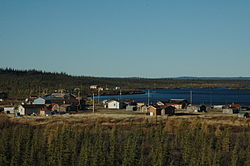
Colville Lake
K'áhbamį́túé | |
|---|---|
Settlement Corporation | |
 | |
| Coordinates: 67°02′18″N 126°05′32″W / 67.03833°N 126.09222°W | |
| Country | Canada |
| Territory | Northwest Territories |
| Region | Sahtu |
| Settlement area | Sahtu |
| Constituency | Sahtu |
| First Nation (Designated Authority) | 30 November 1995 |
| Government | |
| • Chief | Wilbert Kochon |
| • Senior Administrative Officer | Joseph Kochon |
| • MLA | Norman Yakeleya |
| Area | |
| • Land | 128.39 km2 (49.57 sq mi) |
| Elevation | 259 m (850 ft) |
| Population (2016)[1] | |
| • Total | 129 |
| • Density | 1.0/km2 (3/sq mi) |
| Time zone | UTC−07:00 (MST) |
| • Summer (DST) | UTC−06:00 (MDT) |
| Canadian Postal code | X0E 1L0 |
| Area code | 867 |
| Telephone exchange | 709 |
| - Living cost | 182.5A |
| - Food price index | 196.3B |
| Sources: Department of Municipal and Community Affairs,[2] Prince of Wales Northern Heritage Centre,[3] Canada Flight Supplement[4] ^A 2013 figure based on Edmonton = 100[5] ^B 2015 figure based on Yellowknife = 100[5] | |
Colville Lake (K'áhbamį́túé[pronunciation?] meaning "ptarmigan net place") is a settlement corporation located in the Sahtu Region of the Northwest Territories, Canada. The community is located 50 km (31 mi) north of the Arctic Circle, on a lake of the same name, and is northeast of Norman Wells. This settlement is the administrative office of the Behdzi Ahda band government. The community is likely named for Hudson's Bay Company Governor Andrew Colvile.[6]
- ^ a b Canada, Government of Canada, Statistics. "Census Profile, 2016 Census - Colville Lake, Settlement [Census subdivision], Northwest Territories and Canada [Country]". www12.statcan.gc.ca. Retrieved 2017-09-06.
{{cite web}}: CS1 maint: multiple names: authors list (link) - ^ "NWT Communities - Colville Lake". Government of the Northwest Territories: Department of Municipal and Community Affairs. Retrieved 2014-01-21.
- ^ "Northwest Territories Official Community Names and Pronunciation Guide". Prince of Wales Northern Heritage Centre. Yellowknife: Education, Culture and Employment, Government of the Northwest Territories. Archived from the original on 2016-01-13. Retrieved 2016-01-13.
- ^ Canada Flight Supplement. Effective 0901Z 16 July 2020 to 0901Z 10 September 2020.
- ^ a b "Colville Lake - Statistical Profile (2006-2017)" (PDF). NWT Bureau of Statistics. Archived (PDF) from the original on 2018-08-29.
- ^ "Colville Lake". Srrb.nt.ca. 2015-04-21. Retrieved 2022-03-13.

