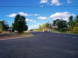
| Condamine Queensland | |||||||||||||||
|---|---|---|---|---|---|---|---|---|---|---|---|---|---|---|---|
 The Leichhardt Highway, passing through Condamine | |||||||||||||||
| Coordinates | 26°55′33″S 150°08′11″E / 26.9258°S 150.1363°E | ||||||||||||||
| Population | 294 (2021 census)[1] | ||||||||||||||
| • Density | 0.3773/km2 (0.9771/sq mi) | ||||||||||||||
| Postcode(s) | 4416 | ||||||||||||||
| Area | 779.3 km2 (300.9 sq mi) | ||||||||||||||
| Time zone | AEST (UTC+10:00) | ||||||||||||||
| Location | |||||||||||||||
| LGA(s) | Western Downs Region | ||||||||||||||
| State electorate(s) | Warrego | ||||||||||||||
| Federal division(s) | Maranoa | ||||||||||||||
| |||||||||||||||
Condamine is a rural town and locality in the Western Downs Region, Queensland, Australia.[2][3] In the 2021 census, the locality of Condamine had a population of 294 people.[1]
Condamine is claimed to be the location of the invention of the Condamine Bell, a small bell made from sheet metal used to locate herds of cattle.[4][5][6]
- ^ a b Cite error: The named reference
Census2021was invoked but never defined (see the help page). - ^ "Condamine – town in Western Downs Region (entry 7875)". Queensland Place Names. Queensland Government. Retrieved 21 July 2021.
- ^ "Condamine – locality in Western Downs Region (entry 50107)". Queensland Place Names. Queensland Government. Retrieved 21 July 2021.
- ^ "Condamine, Queensland". AboutAustralia.com.au. Archived from the original on 17 April 2011. Retrieved 15 September 2010.
- ^ "A short history of the Condamine Bull Frog Bell" (PDF). Maleny Historical Memories. Retrieved 9 April 2024.
- ^ "Condamine Bell". Tourism & Events Queensland. Queensland Government. Retrieved 9 April 2024.
