This article needs additional citations for verification. (May 2014) |
| Conemaugh River | |
|---|---|
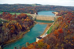
 Conemaugh River Lake Dam at low water | |
 | |
| Location | |
| Country | United States |
| Physical characteristics | |
| Source | |
| • coordinates | 40°19′54″N 78°55′30″W / 40.3317406°N 78.9250255°W |
| Mouth | |
• coordinates | 40°29′08″N 79°27′14″W / 40.4856220°N 79.4539299°W |
• elevation | 827 ft (252 m) |
| Discharge | |
| • location | Tunnelton |
| • average | 2,431 cu ft/s (68.8 m3/s)[1] |
| Basin features | |
| River system | Allegheny River |
The Conemaugh River is a 70-mile (110 km) tributary of the Kiskiminetas River in Westmoreland, Indiana, and Cambria counties in the U.S. state of Pennsylvania.[2] The name means 'Otter Creek', originating from the Unami-Lenape language word kwənəmuxkw 'otter'.[3][4][5]
- ^ "USGS Surface Water data for Pennsylvania: USGS Surface-Water Annual Statistics".
- ^ "Conemaugh River". Geographic Names Information System. United States Geological Survey, United States Department of the Interior. Retrieved 2011-04-27.
- ^ Linder, Lee (Jul 9, 1970). "Happenings in Pennsylvania". Observer-Reporter. pp. B3. Retrieved 23 May 2015.
- ^ Storey, Henry Wilson (1907). History of Cambria County, Pennsylvania. Vol. 1. New York: Lewis. p. 63. Retrieved June 10, 2016.
- ^ "kwënëmuxkw". Lenape Talking Dictionary. Archived from the original on February 1, 2016. Retrieved June 10, 2016.