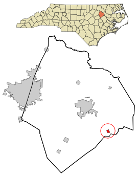
Conetoe, North Carolina | |
|---|---|
 Location in Edgecombe County and the state of North Carolina. | |
| Coordinates: 35°49′04″N 77°27′26″W / 35.81778°N 77.45722°W | |
| Country | United States |
| State | North Carolina |
| County | Edgecombe |
| Incorporated | 1887[1] |
| Named for | Conetoe Creek[1] |
| Area | |
| • Total | 0.34 sq mi (0.89 km2) |
| • Land | 0.34 sq mi (0.89 km2) |
| • Water | 0.00 sq mi (0.00 km2) |
| Elevation | 46 ft (14 m) |
| Population (2020) | |
| • Total | 198 |
| • Density | 577.26/sq mi (222.82/km2) |
| Time zone | UTC-5 (Eastern (EST)) |
| • Summer (DST) | UTC-4 (EDT) |
| ZIP code | 27819 |
| Area code | 252 |
| FIPS code | 37-14200[4] |
| GNIS feature ID | 2406305[3] |
Conetoe (/kəˈniːtə/ kə-NEE-tə)[5] is a town in Edgecombe County, North Carolina, United States. It is part of the Rocky Mount, North Carolina Metropolitan Statistical Area. The population was 294 at the 2010 census.
- ^ a b "North Carolina Gazetteer". Retrieved December 19, 2022.
- ^ "ArcGIS REST Services Directory". United States Census Bureau. Retrieved September 20, 2022.
- ^ a b U.S. Geological Survey Geographic Names Information System: Conetoe, North Carolina
- ^ "U.S. Census website". United States Census Bureau. Retrieved January 31, 2008.
- ^ "Talk Like a Tar Heel". Wilson Library. Retrieved August 16, 2022.