| Congaree National Park | |
|---|---|
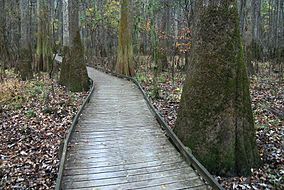
 Boardwalk passes through old growth forest of bald cypress and water tupelo | |
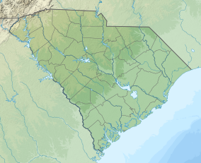
| Location | Richland County, South Carolina, United States |
| Nearest city | Eastover, South Carolina (town) |
| Coordinates | 33°47′0″N 80°47′0″W / 33.78333°N 80.78333°W |
| Area | 26,692.6 acres (108.021 km2)[2] |
| Max. elevation | 140 feet (43 m)[3] |
| Min. elevation | 80 feet (24 m) |
| Established | November 10, 2003 |
| Visitors | 145,929 (in 2018)[4] |
| Governing body | National Park Service |
| Website | nps |
| Designated | 2 February 2012 |
| Reference no. | 2030[5] |
| Designated | May 1974 |
Congaree National Park is a 26,692.6-acre (41.7 sq mi; 108.0 km2) national park of the United States in central South Carolina, 18 miles southeast of the state capital, Columbia. The park preserves the largest tract of old growth bottomland hardwood forest left in the United States. The lush trees growing in its floodplain forest are some of the tallest in the eastern United States, forming one of the highest temperate deciduous forest canopies remaining in the world. The Congaree River flows through the park. About 15,000 acres (23.4 sq mi; 60.7 km2) are designated as a wilderness area.
The park received its official designation in 2003 as the culmination of a grassroots campaign that began in 1969. With 145,929 visitors in 2018, it ranks as the United States' 10th-least visited national park, just behind Nevada's Great Basin National Park.[6]
- ^ "Protected Planet | Congaree National Park". Protected Planet. Archived from the original on 2020-10-20. Retrieved 2020-10-20.
- ^ "Listing of acreage – December 31, 2021" (XLSX). Land Resource Division, National Park Service. Retrieved 2022-07-03. (National Park Service Acreage Reports)
- ^ "Congaree". National Parked. March 13, 2021. Retrieved 7 October 2021.
- ^ "NPS Annual Recreation Visits Report". National Park Service. Retrieved March 6, 2019.
- ^ "Congaree National Park". Ramsar Sites Information Service. Archived from the original on 14 June 2018. Retrieved 25 April 2018.
- ^ Reed, Shannon (25 March 2020). "The Least-Visited National Parks — and Why They're Worth a Look". www.farandwide.com. Archived from the original on 15 February 2021. Retrieved 27 January 2021.

