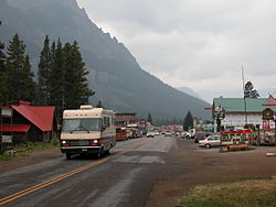
Cooke City, Montana | |
|---|---|
 Entering Cooke City from the east | |
| Coordinates: 45°1′10″N 109°56′4″W / 45.01944°N 109.93444°W | |
| Country | United States |
| State | Montana |
| County | Park |
| Area | |
• Total | 9.54 sq mi (24.70 km2) |
| • Land | 9.54 sq mi (24.70 km2) |
| • Water | 0.00 sq mi (0.00 km2) |
| Elevation | 7,580 ft (2,310 m) |
| Population (2020) | |
• Total | 77 |
| • Density | 8.08/sq mi (3.12/km2) |
| Time zone | UTC-7 (Mountain (MST)) |
| • Summer (DST) | UTC-6 (MDT) |
| ZIP Code | 59020 |
| Area code | 406 |
| FIPS code | 30-17350 |
| GNIS feature ID | 2583800[2] |
Cooke City is an unincorporated community and census-designated place (CDP) in Park County, Montana, United States. As of the 2020 census, it had a population of 77.[3] Prior to 2010, it was part of the Cooke City-Silver Gate CDP.
The community sits northeast of Yellowstone National Park on the Beartooth Highway, which leads east to Red Lodge, Montana, on a scenic route climbing to 10,947 feet (3,337 m) in elevation through the Beartooth Mountains and across the Beartooth Plateau. The town's chief industry is tourism, which during the winter includes skiing and snowmobiling.
It is named for Jay Cooke, financier of the Northern Pacific Railroad.[4]
- ^ "ArcGIS REST Services Directory". United States Census Bureau. Retrieved September 5, 2022.
- ^ "Cooke City Census Designated Place". Geographic Names Information System. United States Geological Survey, United States Department of the Interior.
- ^ "Cooke City CDP, Montana". data.census.gov. U.S. Census Bureau. Retrieved April 11, 2023.
- ^ "Cooke City". Montana Place Names Companion. Montana Historical Society. Retrieved April 2, 2021.

