Corbin, Kentucky | |
|---|---|
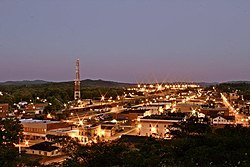
 Downtown Corbin, Kentucky, from North Kentucky Street, looking South down Main Street | |
 Location of Corbin in Whitley County, Kentucky. | |
| Coordinates: 36°55′56″N 84°06′02″W / 36.93222°N 84.10056°W | |
| Country | United States |
| State | Kentucky |
| Counties | Whitley, Knox, Laurel |
| Government | |
| • Type | Mayor-commission |
| • Mayor | Suzie Razmus |
| • City Manager | Marlon Sams |
| Area | |
| • Total | 7.99 sq mi (20.70 km2) |
| • Land | 7.95 sq mi (20.59 km2) |
| • Water | 0.04 sq mi (0.11 km2) |
| Elevation | 1,119 ft (341 m) |
| Population (2020) | |
| • Total | 7,856 |
| • Estimate (2023)[3] | 9,012 |
| • Density | 988.42/sq mi (381.64/km2) |
| Time zone | UTC-5 (Eastern (EST)) |
| • Summer (DST) | UTC-4 (EDT) |
| ZIP codes | 40701-40702 |
| Area code | 606 |
| FIPS code | 21-17362 |
| GNIS feature ID | 2404128[2] |
| Website | corbin-ky.gov |
Corbin is a home rule-class city[4] in Whitley, Knox and Laurel counties in the southeastern portion of the U.S. state of Kentucky. As of the 2020 census, the city population was 7,856.
Corbin is on Interstate 75 and US Route 25W, about halfway between Knoxville, Tennessee, and Lexington, Kentucky.
- ^ "2020 U.S. Gazetteer Files". United States Census Bureau. Retrieved March 18, 2022.
- ^ a b U.S. Geological Survey Geographic Names Information System: Corbin, Kentucky
- ^ "Annual Estimates of the Resident Population for Incorporated Places in Kentucky: April 1, 2020 to July 1, 2022". United States Census Bureau. Retrieved May 26, 2023.
- ^ "Summary and Reference Guide to House Bill 331 City Classification Reform" (PDF). Kentucky League of Cities. Retrieved December 30, 2014.


