| Corpus Christi Bay | |
|---|---|
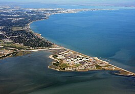
 Corpus Christi Bay (right), Nueces Bay (top), and Oso Bay (bottom) | |
| Location | South Texas Gulf Coast |
| Coordinates | 27°46′20″N 97°15′10″W / 27.77222°N 97.25278°W |
| River sources | Nueces River, Oso Creek |
| Ocean/sea sources | Gulf of Mexico |
| Basin countries | United States |
| Surface area | 106,990 acres (43,300 ha)[1] |
| Settlements | Corpus Christi, Portland, Ingleside, Ingleside on the Bay |
Corpus Christi Bay is a scenic semi-tropical bay on the Texas coast found in San Patricio and Nueces counties, next to the major city of Corpus Christi. It is separated from the Gulf of Mexico by Mustang Island, and is fed by the Nueces River and Oso Creek from its western and southern extensions, Nueces Bay and Oso Bay. The bay is located approximately 136 miles (219 km) south of San Antonio, and 179 miles (288 km) southwest of Houston.
Corpus Christi Bay has a rich history of human settlement along its shores that dates back millennia and is responsible for the growth of Corpus Christi, and the smaller ports of Ingleside and Portland. It is one of seven major estuaries along the Gulf Coast of Texas and supports a diverse collection of wildlife, attracting many tourists. The bay's abundance of petroleum and natural gas has attracted industry, and its strategic location on the Texas coast is ideal for military establishment.
- ^ "Nueces Estuary (Corpus Christi Bay)". Texas Water Development Board. Retrieved February 7, 2020.
