Coryell County | |
|---|---|
 The Coryell County Courthouse in Gatesville, Texas. The courthouse was added to the National Register of Historic Places on August 18, 1977. | |
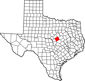
 Location within the U.S. state of Texas | |
 Texas's location within the U.S. | |
| Coordinates: 31°23′N 97°48′W / 31.39°N 97.8°W | |
| Country | |
| State | |
| Founded | 1854 |
| Seat | Gatesville |
| Largest city | Copperas Cove |
| Area | |
| • Total | 1,057 sq mi (2,740 km2) |
| • Land | 1,052 sq mi (2,720 km2) |
| • Water | 4.7 sq mi (12 km2) 0.4% |
| Population (2020) | |
| • Total | 83,093 |
| • Density | 79/sq mi (30/km2) |
| Time zone | UTC−6 (Central) |
| • Summer (DST) | UTC−5 (CDT) |
| Congressional district | 31st |
| Website | www |
Coryell County (/ˈkɔːrjɛl/ KOR-yel)[1] is a county located on the Edwards Plateau in the U.S. state of Texas. As of the 2020 census, its population was 83,093.[2][3] The county seat is Gatesville.[4] The county is named for James Coryell, a frontiersman and Texas Ranger who was killed by Caddo Indians.
Coryell County is part of the Killeen–Temple metropolitan statistical area.
- ^ "Archived copy". Archived from the original on August 18, 2014. Retrieved November 28, 2012.
{{cite web}}: CS1 maint: archived copy as title (link) - ^ "U.S. Census Bureau QuickFacts: Coryell County, Texas". United States Census Bureau. Retrieved January 31, 2022.
- ^ "Coryell County, Texas". United States Census Bureau. Retrieved February 23, 2021.
- ^ "Find a County". National Association of Counties. Archived from the original on May 9, 2015. Retrieved June 7, 2011.