| Cottonwood Creek | |
|---|---|
 Cottonwood Creek | |
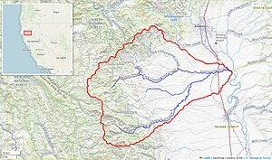
 Cottonwood Creek watershed (Interactive map) | |
| Location | |
| Country | United States |
| State | California |
| Physical characteristics | |
| Source | Confluence of North and Middle Forks |
| • location | near Janesville |
| • coordinates | 40°23′41″N 122°31′33″W / 40.39472°N 122.52583°W[1] |
| • elevation | 541 ft (165 m) |
| Mouth | Sacramento River |
• location | about 5 miles (8.0 km) east of Cottonwood |
• coordinates | 40°22′40″N 122°11′58″W / 40.37778°N 122.19944°W |
• elevation | 341 ft (104 m) |
| Length | 68 mi (109 km)[2] |
| Basin size | 938 sq mi (2,430 km2)[2] |
| Discharge | |
| • location | Cottonwood, about 2.5 miles (4.0 km) from the mouth[3] |
| • average | 874 cu ft/s (24.7 m3/s)[3] |
| • minimum | 15 cu ft/s (0.42 m3/s) |
| • maximum | 86,000 cu ft/s (2,400 m3/s) |
| Basin features | |
| Tributaries | |
| • left | North Fork Cottonwood Creek, Antelope Creek, Dry Creek |
| • right | Middle Fork Cottonwood Creek, Little Dry Creek, South Fork Cottonwood Creek, Patterson Creek |
Cottonwood Creek is a major stream and tributary of the Sacramento River in Northern California. About 68 miles (109 km) long measured to its uppermost tributaries, the creek drains a large rural area bounded by the crest of the Coast Ranges, traversing the northwestern Sacramento Valley before emptying into the Sacramento River near the town of Cottonwood. It defines the boundary of Shasta and Tehama counties for its entire length. Because Cottonwood Creek is the largest undammed tributary of the Sacramento River, it is known for its Chinook salmon and steelhead runs.[2]
- ^ "Cottonwood Creek". Geographic Names Information System. United States Geological Survey, United States Department of the Interior. 1981-01-19. Retrieved 2015-11-23.
- ^ a b c "Cottonwood Creek". California Salmon Snapshots. The Nature Conservancy. Retrieved 2015-11-22.
- ^ a b "USGS Gage #11376000 on Cottonwood Creek near Cottonwood, CA" (PDF). National Water Information System. U.S. Geological Survey. 2013. Retrieved 2015-11-23.