County Westmeath
Contae na hIarmhí | |
|---|---|
| Nickname: The Lake County | |
| Motto(s): | |
 | |
| Country | Ireland |
| Province | Leinster |
| Region | Eastern and Midland |
| Established | 1542[1] |
| County town | Mullingar |
| Largest settlement | Athlone |
| Government | |
| • Local authority | Westmeath County Council |
| • Dáil constituencies | |
| • EP constituency | Midlands–North-West |
| Area | |
| • Total | 1,840 km2 (710 sq mi) |
| • Rank | 21st |
| Highest elevation | 258 m (846 ft) |
| Population (2022)[2] | |
| • Total | 95,840 |
| • Rank | 22nd |
| • Density | 52/km2 (130/sq mi) |
| Time zone | UTC±0 (WET) |
| • Summer (DST) | UTC+1 (IST) |
| Eircode routing keys | N37, N91 (primarily) |
| Telephone area codes | 044, 090 (primarily) |
| ISO 3166 code | IE-WH |
| Vehicle index mark code | WH |
 | |
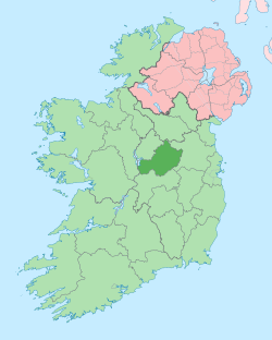
County Westmeath (/wɛstˈmiːð/; Irish: Contae na hIarmhí or simply An Iarmhí) is a county in Ireland. It is in the province of Leinster and is part of the Eastern and Midland Region. It formed part of the historic Kingdom of Meath, which was named Mide because the kingdom was located in the geographical centre of Ireland (the word Mide meaning 'middle').[3] Westmeath County Council is the administrative body for the county, and the county town is Mullingar. At the 2022 census, the population of the county was 95,840.[2]
- ^ "'Geographical loyalty'? Counties, palatinates, boroughs and ridings". 6 March 2013. Archived from the original on 23 June 2019. Retrieved 23 June 2019.
- ^ a b "Census of Population 2022 – Preliminary Results". Central Statistics Office (Ireland). 23 June 2022. Retrieved 26 May 2023.
- ^ "Kingdom of Mide". Archived from the original on 5 October 2012. Retrieved 16 June 2011.
