Courcelles
Courcele (Walloon) | |
|---|---|
 St. Lambert's church | |
| Coordinates: 50°28′N 04°22′E / 50.467°N 4.367°E | |
| Country | |
| Community | French Community |
| Region | Wallonia |
| Province | Hainaut |
| Arrondissement | Charleroi |
| Government | |
| • Mayor | Caroline Taquin (MR) |
| • Governing party/ies | MR, CDH, Ecolo |
| Area | |
• Total | 44.52 km2 (17.19 sq mi) |
| Population (2018-01-01)[1] | |
• Total | 31,376 |
| • Density | 700/km2 (1,800/sq mi) |
| Postal codes | 6180-6183 |
| NIS code | 52015 |
| Area codes | 071 |
| Website | www.courcelles.be |
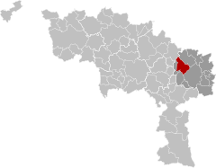
Courcelles (French pronunciation: [kuʁsɛl] ; Walloon: Courcele) is a municipality of Wallonia located in the province of Hainaut, Belgium.
As of January 1, 2006, Courcelles had a total population of 29,626. The total area is 44.24 km2 which gives a population density of 670 inhabitants per km2.
The municipality consists of the following districts: Courcelles, Gouy-lez-Piéton, Souvret, and Trazegnies.
In 1944, the town was the site of the Courcelles Massacre of 20 civilians by Belgian collaborators. The event is commemorated by a plaque at the site.

- ^ "Wettelijke Bevolking per gemeente op 1 januari 2018". Statbel. Retrieved 9 March 2019.


