You can help expand this article with text translated from the corresponding article in German. (July 2011) Click [show] for important translation instructions.
|
This article needs additional citations for verification. (February 2017) |
Cova Lima | |
|---|---|
| |
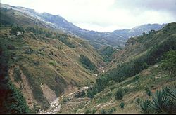
 Mountain area in Cova Lima | |
 | |
| Coordinates: 9°19′S 125°15′E / 9.317°S 125.250°E | |
| Country | |
| Capital | Suai |
| Administrative posts | |
| Area | |
| • Total | 1,198.6 km2 (462.8 sq mi) |
| • Rank | 7th |
| Population (2015 census) | |
| • Total | 65,301 |
| • Rank | 9th |
| • Density | 54/km2 (140/sq mi) |
| • Rank | 9th |
| Households (2015 census) | |
| • Total | 12,564 |
| • Rank | 8th |
| Time zone | UTC+09:00 (TLT) |
| ISO 3166 code | TL-CO |
| HDI (2017) | 0.618[1] medium · 3rd |
| Website | Cova Lima Municipality |
Cova Lima (Portuguese: Município Cova Lima, Tetum: Munisípiu Kovalima) is a municipality of East Timor, in the Southwest part of the country. It has a population of 59,455 (Census 2010) and an area of 1,230 km2.[2] The capital of the municipality is Suai, which lies 136 km from Dili, the national capital.[3]
- ^ "Sub-national HDI - Area Database - Global Data Lab". hdi.globaldatalab.org. Retrieved 13 September 2018.
- ^ "Friends of Suai/Covalima" (PDF). City of Port Phillip. May 2014. Archived from the original (PDF) on 25 March 2016. Retrieved 22 February 2017.
- ^ "Friends of Suai: Strategic Plan: 2010 to 2020" (PDF). City of Port Phillip. Archived from the original (PDF) on 1 April 2016. Retrieved 22 February 2017.


