| Crane Mountain | |
|---|---|
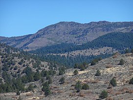
 West face of Crane Mountain | |
| Highest point | |
| Elevation | 8,451 ft (2,576 m) NAVD 88[1] |
| Prominence | 2,336 ft (712 m)[2] |
| Listing | Oregon county high points |
| Coordinates | 42°03′46″N 120°14′27″W / 42.062818347°N 120.240832017°W[1] |
| Geography | |
| Location | Lake County, Oregon, U.S. |
| Parent range | Warner Mountains |
| Topo map | USGS Crane Mountain |
| Geology | |
| Mountain type | Fault block |
| Climbing | |
| Easiest route | Steep rough road |
| Normal route | Hiking trail |
Crane Mountain is in the Warner Mountain range and is the tallest peak in Lake County, Oregon, U.S. It is located southeast of Lakeview in south-central Oregon, near the northwest corner of the Basin and Range Province of the western United States. The mountain is in the Fremont section of the Fremont–Winema National Forest. There was a United States Forest Service fire lookout located near the summit which was removed in 1972.[3] The Crane Mountain National Recreation Trail runs north and south along the crest of the mountain.[4]
- ^ a b "Crane". NGS Data Sheet. National Geodetic Survey, National Oceanic and Atmospheric Administration, United States Department of Commerce. Retrieved 2016-04-12.
- ^ "Crane Mountain, Oregon". Peakbagger.com. Retrieved 2016-04-12.
- ^ "Crane Mountain Lookout Site". Forest Fire Lookout Association. Archived from the original on 2016-03-04.
- ^ "Crane Mountain National Recreation Trail #161". Fremont-Winema National Forest. Retrieved 2016-05-01.
