Crawfordville, Florida | |
|---|---|
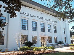
 Wakulla County Courthouse | |
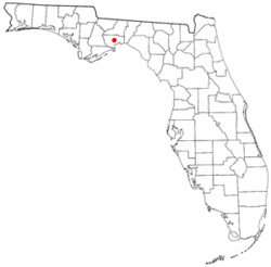
 Location in Wakulla County and the state of Florida | |
| Coordinates: 30°10′34″N 84°22′31″W / 30.17611°N 84.37528°W | |
| Country | |
| State | |
| County | Wakulla |
| Area | |
| 4.57 sq mi (11.83 km2) | |
| • Land | 4.57 sq mi (11.83 km2) |
| • Water | 0.00 sq mi (0.00 km2) |
| • Urban | 9.72 sq mi (25.17 km2) |
| Elevation | 13 ft (4 m) |
| Population (2020) | |
| 4,853 | |
| • Density | 1,062.16/sq mi (410.14/km2) |
| • Urban | 10,124 |
| • Urban density | 1,041.67/sq mi (402.22/km2) |
| Time zone | UTC-5 (Eastern (EST)) |
| • Summer (DST) | UTC-4 (EDT) |
| ZIP codes | 32327 |
| Area code | 850 |
| FIPS code | 12-15300 |
| GNIS feature ID | 2583338 |
Crawfordville is an unincorporated community, census-designated place (CDP), and county seat of Wakulla County, Florida, United States. The population at the 2020 census was 4,853, up from 3,702 at the 2010 census.[2] It is part of the Tallahassee, Florida Metropolitan Statistical Area.
- ^ "2020 U.S. Gazetteer Files". United States Census Bureau. Retrieved October 31, 2021.
- ^ "Explore Census Data". data.census.gov. Retrieved May 13, 2024.