Creel | |
|---|---|
City | |
| Creel | |
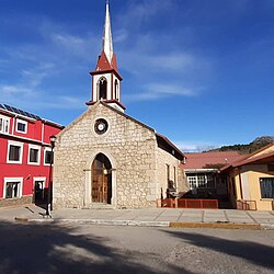
 Cristo Rey Temple in Creel. | |
| Coordinates: 27°45′08″N 107°38′05″W / 27.75222°N 107.63472°W | |
| Country | Mexico |
| State | Chihuahua |
| Municipality | Bocoyna |
| Founded | May 26, 1907 |
| Elevation | 2,350 m (7,710 ft) |
| Population (2010)[1] | |
| • Total | 5,026 |
| Time zone | UTC-7 (MST) |
| • Summer (DST) | UTC-6 (MDT) |
| Area code | 635 |
Creel (Spanish pronunciation: [ˈkɾil]) is a town in the Sierra Tarahumara (part of the Sierra Madre Occidental) of the Mexican state of Chihuahua. It is the second-largest town (after San Juanito) in the municipality of Bocoyna. It is located some 175 kilometres (109 mi) to the southwest of the state capital, Chihuahua City. At the census of 2010, it had a population of 5,026,[2] down from 5,338 as of 2005. It is notable for being inhabited mostly by Native Americans of the Rarámuri ethnic group, and the use of their native language is widespread in the population in daily life and public events such as church masses.
Creel was historically a logging town, although tourism has become the primary job source over the last 20 years because it is close to the Copper Canyon as well as Basaseachic Falls, one of the highest waterfalls in Mexico. There are many hotels, restaurants and a number of tours[3] down into the canyons and throughout the surrounding area.
- ^ "Principales resultados por localidad 2010 (ITER)". Instituto Nacional de Estadística y Geografía. 2010.
- ^ "Bocoyna". Catálogo de Localidades. Secretaría de Desarrollo Social (SEDESOL). Archived from the original on 4 March 2016. Retrieved 23 April 2014.
- ^ "Local Independent Tour Operator".
