| Crooked River | |
|---|---|
 The Crooked River in Smith Rock State Park | |
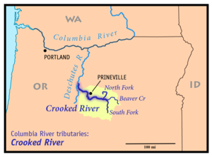
 Map of the Crooked River watershed, its main tributaries and downriver connection to the Columbia River via the Deschutes River. | |
| Location | |
| Country | United States |
| State | Oregon |
| Counties | Jefferson, Deschutes, Crook |
| City | Prineville |
| Physical characteristics | |
| Source | South Fork Crooked River |
| • coordinates | 43°38′55″N 120°23′30″W / 43.64861°N 120.39167°W[1] |
| • elevation | 4,775 ft (1,455 m)[2] |
| Mouth | Deschutes River |
• location | Lake Billy Chinook |
• coordinates | 44°34′25″N 121°16′19″W / 44.57361°N 121.27194°W[3] |
• elevation | 1,950 ft (590 m)[2] |
| Length | 125 mi (201 km)[4] |
| Basin size | 4,500 sq mi (12,000 km2)[5] |
| Discharge | |
| • location | near mouth[6] |
| • average | 1,544 cu ft/s (43.7 m3/s)[6] |
| • minimum | 656 cu ft/s (18.6 m3/s) |
| • maximum | 6,660 cu ft/s (189 m3/s) |
| Basin features | |
| Tributaries | |
| • right | Beaver Creek, North Fork Crooked River, Ochoco Creek |
| Type | Recreational |
| Designated | October 28, 1988 |
The Crooked River is a tributary, 125 miles (201 km) long, of the Deschutes River in the U.S. state of Oregon.[4] The river begins at the confluence of the South Fork Crooked River and Beaver Creek in southeastern Crook County. Of the two tributaries, the South Fork Crooked River is the larger and is sometimes considered part of the Crooked River proper. A variant name of the South Fork Crooked River is simply "Crooked River".[1][3] The Deschutes River flows north into the Columbia River.
- ^ a b U.S. Geological Survey Geographic Names Information System: South Fork Crooked River, USGS, GNIS
- ^ a b Google Earth elevation for GNIS coordinates
- ^ a b U.S. Geological Survey Geographic Names Information System: Crooked River, USGS, GNIS
- ^ a b United States Geological Survey. "United States Topographic Map". Retrieved March 14, 2011 – via AcmeMapper. The map includes river mile markers up to the confluence of the South Fork and Beaver Creek.
- ^ Deschutes Subbasin Plan, Northwest Power and Conservation Council
- ^ a b Water Resources Data for Oregon, Water Year 2005, USGS