Crosswicks, New Jersey | |
|---|---|
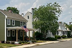
 The J. Ivins House on Church Street, part of the Crosswicks Historic District | |
Location of Crosswicks in Burlington County (Inset: Location of county within the state of New Jersey) | |
| Coordinates: 40°09′12″N 74°38′52″W / 40.15333°N 74.64778°W | |
| Country | |
| State | |
| County | Burlington |
| Township | Chesterfield |
| Area | |
| • Total | 1.84 sq mi (4.78 km2) |
| • Land | 1.82 sq mi (4.73 km2) |
| • Water | 0.02 sq mi (0.05 km2) |
| Elevation | 82 ft (25 m) |
| Population | |
| • Total | 849 |
| • Density | 465.21/sq mi (179.63/km2) |
| Time zone | UTC−05:00 (Eastern (EST)) |
| • Summer (DST) | UTC−04:00 (EDT) |
| Area code(s) | 609, 640 |
| FIPS code | 34-16060[4] |
| GNIS feature ID | 875749[2] |
Crosswicks is an unincorporated community and census-designated place (CDP)[5] located along the Crosswicks Creek in the northern part of Chesterfield Township in Burlington County in the U.S. state of New Jersey.[6][7] The area is served as United States Postal Service ZIP Code 08515.
As of the 2000 United States census, the population for ZIP Code Tabulation Area 08515 was 290.
- ^ "ArcGIS REST Services Directory". United States Census Bureau. Retrieved October 11, 2022.
- ^ a b "Crosswicks". Geographic Names Information System. United States Geological Survey, United States Department of the Interior. Variant name: Crossweeksung
- ^ Census Data Explorer: Crosswicks CDP, New Jersey, United States Census Bureau. Accessed June 15, 2023.
- ^ Geographic Codes Lookup for New Jersey, Missouri Census Data Center. Accessed June 9, 2023.
- ^ State of New Jersey Census Designated Places - BVP20 - Data as of January 1, 2020, United States Census Bureau. Accessed December 1, 2022.
- ^ Genovese, Peter (September 27, 2019). "N.J.'s 33 best small towns, ranked, for the ultimate fall day trip". NJ.com. Retrieved February 18, 2020.
- ^ Locality Search, State of New Jersey. Accessed March 15, 2015.


