| Crow Wing River | |
|---|---|
 The Crow Wing River in Old Wadena County Park | |
 The Crow Wing River | |
| Location | |
| Country | United States |
| State | Minnesota |
| Physical characteristics | |
| Source | |
| • coordinates | 47°00′07″N 94°44′29″W / 47.00194°N 94.74139°W[1] |
| • elevation | 1,391 ft (424 m)[1] |
| Mouth | |
• coordinates | 46°16′16″N 94°20′23″W / 46.27111°N 94.33972°W[2] |
• elevation | 1,145 ft (349 m)[2] |
| Length | 113-mile-long (182 km)[3] |
| Discharge | |
| • location | Pillager, MN |
| • average | 1,574 cu ft/s (44.6 m3/s).[4] |
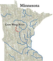
The Crow Wing River is a 113-mile-long (182 km)[5] tributary of the Mississippi River in Minnesota, United States. The river rises at an elevation of about 1391 feet in a chain of 11 lakes in southern Hubbard County, Minnesota, and flows generally south, then east,[6] entering the Mississippi at Crow Wing State Park northwest of Little Falls, Minnesota. Its name is a loose translation from the Ojibwe language Gaagaagiwigwani-ziibi ("Raven-feather River"). A wing-shaped island at its mouth accounts for the river's name.[7] Because of its many campsites and its undeveloped shores, the Crow Wing River is considered one of the state's best "wilderness" routes for canoeists; although it is shallow (seldom more than 3 feet (0.91 m) deep), it is nearly always deep enough for canoeing.[6]
- ^ a b "Geographic Names Information System entry for Eleventh Crow Wing Lake (Feature ID #656140)". Geographic Names Information System. Retrieved 2015-04-07.
- ^ a b "Geographic Names Information System entry for Crow Wing River (Feature ID #655896)". Geographic Names Information System. Retrieved 2010-02-22.
- ^ U.S. Geological Survey Geographic Names Information System: Crow Wing River
- ^ "USGS Surface Water data for Minnesota: USGS Surface-Water Annual Statistics".
- ^ U.S. Geological Survey. National Hydrography Dataset high-resolution flowline data. The National Map Archived 2012-03-29 at the Wayback Machine, accessed November 29, 2012
- ^ a b "Crow Wing River". Retrieved February 20, 2010.
- ^ "Park Info". Retrieved February 20, 2010.