| Crowell | |
|---|---|
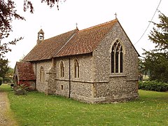
 Parish church of the Nativity of the Blesséd Virgin Mary | |
Location within Oxfordshire | |
| Population | 100 (2001 Census) |
| OS grid reference | SU744997 |
| Civil parish |
|
| District | |
| Shire county | |
| Region | |
| Country | England |
| Sovereign state | United Kingdom |
| Post town | Chinnor |
| Postcode district | OX39 |
| Dialling code | 01844 |
| Police | Thames Valley |
| Fire | Oxfordshire |
| Ambulance | South Central |
| UK Parliament | |
| Website | Crowell Parish Meeting |
Crowell is a village and civil parish in the South Oxfordshire district, in Oxfordshire, England, about 4 miles (6.4 km) southeast of the market town of Thame and 1 mile (1.6 km) southwest of the village of Chinnor. The 2001 Census recorded the parish's population as 100.[1] Crowell village is a spring line settlement at the source of a stream called the Pleck at the foot of the Chiltern Hills escarpment. The toponym "Crowell" is derived from the Old English for "crow's spring" or "crow's stream".[2]
Crowell is a strip parish about 3 miles (5 km) long on a northwest – southeast axis and less than 1⁄2-mile (800 m) wide at its widest point.[2] The northwest part of the strip is low-lying land in the Vale of Oxford about 350 feet (110 m) above sea level; the southeast part of the strip is in the Chilterns and rises to 774 feet (236 m) above sea level. The southeastern part of the parish is bounded on three sides by Buckinghamshire.
- ^ "Area selected: South Oxfordshire (Non-Metropolitan District)". Neighbourhood Statistics: Full Dataset View. Office for National Statistics. Archived from the original on 22 June 2011. Retrieved 11 December 2011.
- ^ a b Lobel 1964, pp. 80–91
