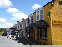
| Crymych | |
|---|---|
 Station Road, Crymych | |
Location within Pembrokeshire | |
| Population | 1,739 (2011)[1] |
| OS grid reference | SN182337 |
| Community |
|
| Principal area | |
| Preserved county | |
| Country | Wales |
| Sovereign state | United Kingdom |
| Post town | WHITLAND |
| Postcode district | SA34 |
| Post town | GLOGUE |
| Postcode district | SA36 |
| Post town | CRYMYCH |
| Postcode district | SA41 |
| Dialling code | 01239 |
| Police | Dyfed-Powys |
| Fire | Mid and West Wales |
| Ambulance | Welsh |
| UK Parliament | |
| Senedd Cymru – Welsh Parliament | |
Crymych () is a village of around 800 inhabitants[2] and a community (population 1,739) in the northeast of Pembrokeshire, Wales. It is situated approximately 800 feet (240 m) above sea level at the eastern end of the Preseli Mountains, on the old Tenby to Cardigan turnpike road, now the A478.
The village developed around the former Crymmych Arms railway station on the now-closed Whitland to Cardigan Railway, nicknamed Cardi Bach (Little Cardi).
Crymych, which is twinned with Plomelin in Brittany, has an elected community council. The village has given its name to an electoral ward of Pembrokeshire that encompasses the villages of Crymych itself and Eglwyswrw. The community includes Hermon, Glandwr, Glogue and Llanfyrnach.
- ^ "Community population 2011". Neighbourhood Statistics. Office for National Statistics. Retrieved 18 April 2015.
- ^ "Crymych housing scheme prompts fears for Welsh language". BBC News. 21 May 2019. Retrieved 21 May 2019.
