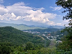
Cullowhee, North Carolina | |
|---|---|
 Cullowhee, the Valley of the Lilies | |
 Location of Cullowhee, North Carolina | |
| Coordinates: 35°18′35″N 83°10′54″W / 35.30972°N 83.18167°W | |
| Country | United States |
| State | North Carolina |
| County | Jackson |
| Area | |
| • Total | 3.81 sq mi (9.86 km2) |
| • Land | 3.81 sq mi (9.86 km2) |
| • Water | 0.00 sq mi (0.00 km2) |
| Elevation | 2,156 ft (657 m) |
| Population (2020) | |
| • Total | 7,682 |
| • Density | 2,017.33/sq mi (778.91/km2) |
| Time zone | UTC-5 (Eastern (EST)) |
| • Summer (DST) | UTC-4 (EDT) |
| ZIP code | 28723 |
| Area code | 828 |
| FIPS code | 37-15880[3] |
| GNIS feature ID | 2402390[2] |
Cullowhee (/ˈkʌləhwiː/[4]) is a census-designated place (CDP) in Jackson County, North Carolina, United States. It is located on the Tuckasegee River, and the permanent population was 7,682 at the 2020 census[5] up from 6,228 at the 2010 census.[6]
The community is the home of Western Carolina University, part of the University of North Carolina System. Developing from a high school and normal school, it has 12,000 students and has become a strong influence in community life. The Jackson County Airport is located just outside the CDP limits.
The present community developed at the site of a historic Cherokee town, which was centered around the earthwork Cullowhee Mound. The name was long thought to mean "Valley of the Lilies." In fact, it is derived from the Cherokee phrase joolth-cullah-wee, which translates as "Judacullah's Place."[7] Judacullah, a giant warrior and hunter who the Cherokee believe lived in the area, is an important figure in their religion and culture.
- ^ "ArcGIS REST Services Directory". United States Census Bureau. Retrieved September 20, 2022.
- ^ a b U.S. Geological Survey Geographic Names Information System: Cullowhee, North Carolina
- ^ "U.S. Census website". United States Census Bureau. Retrieved January 31, 2008.
- ^ "Talk Like a Tarheel" Archived 2013-06-22 at the Wayback Machine, from the North Carolina Collection website at the University of North Carolina at Chapel Hill. Retrieved 2013-01-29.
- ^ "Cullowhee CDP, North Carolina Demographics and Housing 2020 Decennial Census".
- ^ "Geographic Identifiers: 2010 Census Summary File 1 (G001): Cullowhee CDP, North Carolina". American Factfinder. U.S. Census Bureau. Archived from the original on February 13, 2020. Retrieved October 9, 2018.
- ^ "Cherokee instructor discusses possible evolution of word "Cullowhee"". The Reporter. August 25, 2010. Archived from the original on April 9, 2016.