Cumberland | |
|---|---|
| The Corporation of the Village of Cumberland | |
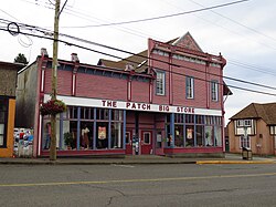
 General store (1894) | |
| Coordinates: 49°37′8″N 125°01′53″W / 49.61889°N 125.03139°W | |
| Country | Canada |
| Province | British Columbia |
| Region | Mid-Island |
| Regional district | Comox Valley |
| Incorporated | 1898 |
| Government | |
| • Governing body | Cumberland Village Council |
| • Mayor | Vicky Brown |
| Area | |
| • Total | 29.11 km2 (11.24 sq mi) |
| Elevation | 160 m (520 ft) |
| Population (2021) | |
| • Total | 4,447 |
| • Density | 128.9/km2 (334/sq mi) |
| Time zone | UTC-8 (PST) |
| Postal code | V0R 1S0 |
| Area codes | 250, 778, 236, & 672 |
| Highways | |
| Website | Cumberland |
Cumberland is an incorporated village municipality east of Perseverance Creek,[1] near the east coast of central Vancouver Island, British Columbia.[2] The Comox Valley community is west of BC Highway 19 and is by road about 105 kilometres (65 mi) northwest of Nanaimo and 10 kilometres (6 mi) southwest of Courtenay.

