Cureghem
| |
|---|---|
Neighbourhood | |
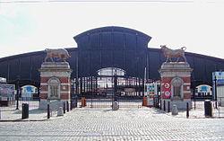
 Entrance and great hall of the Abattoirs of Anderlecht (main slaughterhouse in Brussels) | |
| Coordinates: 50°50′12″N 4°19′44″E / 50.83667°N 4.32889°E | |
| Country | Belgium |
| Region | Brussels-Capital Region |
| Municipality | |
| Time zone | UTC+1 (CET) |
| • Summer (DST) | UTC+2 (CEST) |
| Postal code | 1060, 1070, 1080 |
| Area codes | 02 |
Cureghem (French, pronounced [kyʁəɡɛm]) or Kuregem (Dutch, pronounced [ˈkyrəɣɛm] ) is a district of Brussels, Belgium, located just south-west of the Pentagon (Brussels' city centre).[1] Covering 2 km2 (0.77 sq mi) and with a population of 22,741 inhabitants on 1 January 2009, it is one of the region's largest and most populated districts.[2]
Cureghem roughly covers the area between the Quai de l'Industrie/Nijverheidskaai, railways along Brussels-South railway station and the south-western side of the Small Ring (Brussels' inner ring road).[1][2][3] The territory is thus split between the municipalities of Anderlecht, Molenbeek-Saint-Jean and Saint-Gilles.[2][3][4]
The area developed during the Industrial Revolution along the Brussels–Charleroi Canal and is currently in a fragile social and economic situation due to the decline of its economy and the poor quality of some of its housing.[1][2][5]
- ^ a b c Sacco 2010.
- ^ a b c d De Caluwé, Dirk. "CUREGHEM PARTIE 1 CONTEXTE HISTORIQUE" (PDF). abattoir.be. Retrieved 29 October 2024.
- ^ a b "Quartier de Cureghem | Anderlecht". www.anderlecht.be. Retrieved 25 August 2023.
- ^ "Zoom sur Saint-Gilles | IBSA" (PDF). ibsa.brussels. Retrieved 11 October 2024.
- ^ Cite error: The named reference
Anderlechtwas invoked but never defined (see the help page).

