| Currie Tasmania | |||||||||||||||
|---|---|---|---|---|---|---|---|---|---|---|---|---|---|---|---|
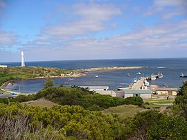
 Currie Harbour, 2007 | |||||||||||||||
| Coordinates | 39°55′52″S 143°51′02″E / 39.93111°S 143.85056°E | ||||||||||||||
| Population | 659 (UCL 2021)[1] | ||||||||||||||
| Postcode(s) | 7256 | ||||||||||||||
| LGA(s) | King Island Council | ||||||||||||||
| Region | North-west and west | ||||||||||||||
| State electorate(s) | Braddon | ||||||||||||||
| Federal division(s) | Braddon | ||||||||||||||
| |||||||||||||||
Currie is a rural residential locality in the local government area (LGA) of King Island in the North-west and west LGA region of Tasmania. The 2021 census recorded a population of 659. It is the largest township on, and is the administrative centre of, King Island, at the western entrance to Bass Strait.
- ^ Australian Bureau of Statistics (28 June 2022). "Currie (urban centre and locality)". Australian Census 2021.
