D'Hanis | |
|---|---|
Census-designated place | |
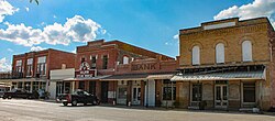
 Historic district in D'Hanis | |
| Nickname: New D'Hanis | |
| Coordinates: 29°19′56″N 99°15′47″W / 29.33222°N 99.26306°W[1] | |
| Country | United States of America |
| State | Texas |
| County | Medina County |
| Founded by | Count von D'Hanis |
| Elevation | 883 ft (269 m) |
| Population (2020) | |
| • Total | 785 |
| Time zone | UTC-6:00 (CST) |
| • Summer (DST) | UTC-5:00 (CDT) |
| GNIS feature ID | 2586924[1] |
D'Hanis (/dəˈhɛnɪs/)[2] is a census-designated place[1] in central Medina County, Texas, United States.[3] It is part of the San Antonio—New Braunfels, Texas Metropolitan Statistical Area. The population was 785 at the 2020 census,[4] up from 548 in 2000.[3] It was primarily settled in the 1800s by German emigrants.[5]
D'Hanis is located at the intersections of U.S. Route 90, Farm to Market Road 1796 and Farm to Market Road 2200[3] on Seco Creek. The community is sometimes called New D'Hanis to distinguish it from the site of old D'Hanis one mile to the east.[3]
- ^ a b c d U.S. Geological Survey Geographic Names Information System: D'Hanis, Texas
- ^ "Texas Almanac, 1956-1957 (The Dallas Morning News)". The Portal to Texas History. May 10, 1955. Retrieved May 10, 2023.
- ^ a b c d D'Hanis, Texas and Old D'Hanis Texas Texas Escapes Online Magazine. Retrieved 8 August 2013.
- ^ "Explore Census Data". data.census.gov. Retrieved August 29, 2024.
- ^ "TSHA | Germans".
