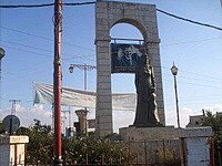
Da'el
داعل | |
|---|---|
 Town Square of Da'el | |
| Coordinates: 32°45′14″N 36°07′48″E / 32.75389°N 36.13000°E | |
| Grid position | 255/240 |
| Country | |
| Governorate | Daraa |
| District | Daraa |
| Subdistrict | Da'el |
| Elevation | 600 m (2,000 ft) |
| Population (2004 census) | |
| • Total | 29,408 |
Da'el (Arabic: داعل, also spelled Da'il) is a town in southern Syria located on the old road between Daraa and Damascus, located approximately 14 kilometers north of Daraa. Administratively, it belongs to the Daraa District of the Daraa Governorate and is the center of the Da'el nahiyah ("subdistrict") which also includes one other town, Abtaa, to the immediate north. Other nearby localities include Tafas to the west, Ataman to the south, Khirbet al-Ghazaleh to the east, Nimer and Qarfa to the northeast, al-Shaykh Maskin to the north and al-Shaykh Saad to the northwest.[1]
As of the 2004 census by the Central Bureau of Statistics (CBS), the population of Da'el town was 29,408, while the Da'el subdistrict was 43,691.[1] Its inhabitants are predominantly Muslims.[2] The inhabitants are mainly involved in agriculture of grains (wheat, beans, olives, grapes, etc.) and expertise manpower in some Persian Gulf countries (UAE, KSA, Kuwait and Qatar).[citation needed]
The city was recently modernized with a new wave of services such as high-speed internet, full cell-phone coverage, new land line phones with a boom in construction field. Government employees do not exceed 5% of the town's population while the rest operate their own businesses.[citation needed]
