Damascus | |
|---|---|
| Damascus, Oregon | |
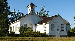
 Old Damascus schoolhouse | |
 Location in Oregon | |
| Coordinates: 45°25′47″N 122°26′46″W / 45.42972°N 122.44611°W | |
| Country | United States |
| State | Oregon |
| County | Clackamas |
| Incorporated | 2004 |
| Area | |
| • Total | 16.14 sq mi (41.80 km2) |
| • Land | 16.04 sq mi (41.54 km2) |
| • Water | 0.10 sq mi (0.26 km2) |
| Elevation | 712 ft (217 m) |
| Population | |
| • Total | 11,050 |
| • Density | 657.0/sq mi (253.7/km2) |
| Time zone | UTC-8 (Pacific) |
| • Summer (DST) | UTC-7 (Pacific) |
| ZIP codes | 97009, 97015, 97030, 97080, 97089 |
| Area code(s) | 503 and 971 |
| GNIS feature ID | 2410292[3] |
Preview warning: Page using Template:Infobox settlement with unknown parameter "elevation_ footnotes"
Damascus (/dəˈmæskəs/ də-MAS-kəs) is a census-designated place and former city in Clackamas County, Oregon, United States. Established in 1867, it was incorporated in 2004 in an effort to enable local land use decision-making control by the community. Its residents voted to disincorporate in 2016, and, after a legal challenge, its disincorporation was completed in 2020. Damascus is located east of Happy Valley and Interstate 205 and west of Boring. The population was 11,050 residents as of the 2020 census.