Dang District
Dandakaranya | |
|---|---|
 Lakes near Saputara | |
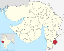
 Location of Dang district in Gujarat | |
| Coordinates: 20°45′31.7″N 73°41′19.0″E / 20.758806°N 73.688611°E | |
| Country | |
| State | Gujarat |
| Headquarters | Ahwa |
| Area | |
| • Total | 1,764 km2 (681 sq mi) |
| Population (2011) | |
| • Total | 228,291 |
| • Density | 130/km2 (340/sq mi) |
| Languages | |
| • Official | Gujarati, Hindi, English |
| • Spoken | Khandeshi, Gujarati, Bhili, Marathi, Hindi |
| Time zone | UTC+5:30 (IST) |
| Website | dangs |
Dang is a district in the southeastern part of the state of Gujarat in western India. The administrative headquarters of the district are located in Ahwa. Dang has an area of 1,764 km2 and a population of 228,291 (as of 2011).[1] As of 2011, it is the least populous of Gujarat's 33 districts.[2] As per the Planning Commission, Dang is one of the most economically distressed district out of 640 districts in India.[3][4] 94% of the population belongs to one of the scheduled tribes.[5][6] The five Kings of Dangs are the only hereditary royals in India whose titles are currently recognized by the government owing to an agreement between the Government of India and the Dang kings in 1842.[7][8]
- ^ "Census GIS India". Archived from the original on 2007-07-03. Retrieved 2009-08-27.
- ^ "District Census Hand Book – Dangs" (PDF). Census of India. Registrar General and Census Commissioner of India.
- ^ "Governance in Gujarat Under Modi - A Critique"
- ^ "In Gujarat's Dangs District, Tribals Are Left With No Option but to Migrate For Survival". News18. 5 April 2019. Retrieved 21 October 2022.
- ^ "About Dang".
- ^ "Konkanian Origin of the 'East Indians'".
- ^ Cite error: The named reference
history1was invoked but never defined (see the help page). - ^ "DNA India | Latest News, Live Breaking News on India, Politics, World, Business, Sports, Bollywood". DNA India. Retrieved 2021-12-28.
