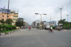
Dankuni
ডানকুনি | |
|---|---|
City | |
 T.N. Mukherjee Road, Durgapur Expressway, Dankuni | |
| Coordinates: 22°41′07″N 88°17′32″E / 22.6854°N 88.2922°E | |
| Country | |
| State | West Bengal |
| Division | Burdwan |
| District | Hooghly |
| Subdivision | Serampore |
| Government | |
| • Type | Municipality |
| • Body | Dankuni Municipality |
| • Chairperson | Hasina Shabnam |
| Area | |
• Total | 35 km2 (14 sq mi) |
| Elevation | 7.9 m (25.9 ft) |
| Population (2011)[1] | |
• Total | 249,840 |
| • Rank | 11th in West Bengal |
| • Density | 7,100/km2 (18,000/sq mi) |
| Demonym | Dankunian |
| Languages | |
| • Official | Bengali, English |
| Time zone | UTC+5:30 (IST) |
| PIN | 711205, 712310, 712311, 712702 and 712708 |
| Telephone code | +91 33 |
| Vehicle registration | WB-18 |
| Website | http://dankunimunicipality.in/ |
Dankuni is a city and a municipality of Hooghly district in the Indian state of West Bengal. It is a part of the area covered by Kolkata Metropolitan Development Authority (KMDA).[2] Positioned strategically near Kolkata, it has emerged as an important industrial and commercial center in the region. The city's landscape is characterized by a mix of residential areas and industrial zones, reflecting its dual identity as a place of habitation and economic activity.
- ^ "censusindia.gov.in".
- ^ "Base Map of Kolkata Metropolitan area". Kolkata Metropolitan Development Authority. Archived from the original on 28 September 2007. Retrieved 3 September 2007.

