DeRuyter, New York | |
|---|---|
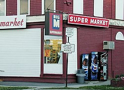
 Old N.Y. State Highway signs at the corner of Utica and Cortland Streets (NYS Rt. 13) in the Village of DeRuyter. The building was the DeRuyter Big M. July 2001 photo. | |
| Coordinates: 42°45′32″N 75°53′6″W / 42.75889°N 75.88500°W | |
| Country | United States |
| State | New York |
| County | Madison |
| Area | |
| • Total | 0.37 sq mi (0.96 km2) |
| • Land | 0.37 sq mi (0.96 km2) |
| • Water | 0.00 sq mi (0.00 km2) |
| Elevation | 1,286 ft (392 m) |
| Population (2020) | |
| • Total | 408 |
| • Density | 1,105.69/sq mi (427.06/km2) |
| Time zone | UTC-5 (Eastern (EST)) |
| • Summer (DST) | UTC-4 (EDT) |
| ZIP code | 13052 |
| Area code | 315 |
| FIPS code | 36-20390 |
| GNIS feature ID | 0948102 |
| Website | www |
DeRuyter /dəˈraɪtər/ is a village located in the Town of DeRuyter in Madison County, New York, United States. The population was 558 at the 2010 census. The village and town are named after Michiel Adriaenszoon de Ruyter, a famous admiral in the Dutch navy.
The Village of DeRuyter is located in the southwestern corner of the town of DeRuyter on Route 13.
- ^ "ArcGIS REST Services Directory". United States Census Bureau. Retrieved September 20, 2022.
