Degollado Los Altos | |
|---|---|
Municipality and town | |
 | |
| Nickname: La Puerta de Los Altos de Jalisco | |
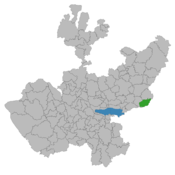
 Location within the state of Jalisco | |
 Jalisco's location within Mexico | |
| Coordinates: 20°28′00″N 102°09′00″W / 20.466667°N 102.15°W | |
| Country | |
| State | Jalisco |
| Municipality | Degollado |
| Founded | 1848 (Toribio de Bolaños) |
| Government | |
| • Mayor | Antonio Medina |
| Area | |
| • Total | 426.7 km2 (164.7 sq mi) |
| • Town | 5.27 km2 (2.03 sq mi) |
| Population (2020 census)[1] | |
| • Total | 21,226 |
| • Density | 50/km2 (130/sq mi) |
| • Town | 11,612 |
| • Town density | 2,200/km2 (5,700/sq mi) |
| Time zone | UTC-6 (Central (US Central)) |
| • Summer (DST) | UTC-5 (Central) |
| Postal code | 47980 |
| Area code | (52) 345 |
| Website | www.degollado.gob.mx[1] |
Degollado (Spanish: [deɣoˈʝaðo]) is a small town and municipality located in the Mexican state of Jalisco, in the cultural region of Ciénega, just south of Los Altos. The town is mainly rural in nature, but the municipality encompasses several concentrated residential areas, such as Huascato, Los Ranchitos, La Vibora, Buenos Aires, Las Limas, Altamira, La Chancla and El Corral de Piedra.
The town is named after Mexican general Santos Degollado.[2] A statue of him is in the Jardin de Niños which was made from coins from the townspeople during the early 1960s.
- ^ Citypopulation.de Population of Degollado municipality with localities
- ^ "Enciclopedia de los Municipios de México - ESTADO DE JALISCO - DEGOLLADO" (in Spanish). Archived from the original on 2007-03-28. Retrieved 2011-05-25.
