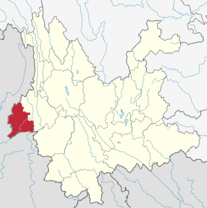
Dehong Dai and Jingpo Autonomous Prefecture | |
|---|---|
| Name transcription(s) | |
| • Chinese | 德宏傣族景颇族自治州 |
| • Tai Nuea | ᥟᥪᥒᥱ ᥙᥪᥴ ᥓᥝᥲ ᥙᥩᥒ ᥛᥥᥝᥰ ᥖᥭᥰ ᥓᥤᥒ ᥚᥨᥝᥲ ᥖᥬᥲ ᥑᥨᥒᥰ |
| • Jingpo | Sakhkung Sam Jinghpo Amyu Madu Uphkang Mungdo |
| Etymology: From Tai Nuea Taue Xoong (ᥖᥬᥲ ᥑᥨᥒᥰ), meaning "the lower reaches of the Nu River" | |
| Nickname: Home of the peafowls | |
 Dehong in Yunnan | |
| Coordinates (Dehong Prefecture government): 24°25′59″N 98°35′08″E / 24.4331°N 98.5856°E | |
| Country | People's Republic of China |
| Province | Yunnan |
| Founded | 24 July 1953 |
| Seat | Mangshi |
| Divisions |
|
| Government | |
| • Prefecture governor | Wei Gang (卫岗)[1] |
| • Secretary of CCP Prefecture Committee | Wang Junqiang (王俊强)[2] |
| Area [3]: 536 | |
| • Total | 11,172.24 km2 (4,313.63 sq mi) |
| • Rank | 16 |
| Dimensions [4]: 97 | |
| • Length | 170 km (110 mi) |
| • Width | 122 km (76 mi) |
| Elevation | 920 m (3,020 ft) |
| Highest elevation [4]: 106 (Daniang Mountain) | 3,404.6 m (11,169.9 ft) |
| Lowest elevation [4]: 106 (Jieyang river valley) | 210 m (690 ft) |
| Population | |
| • Total | 1,211,440 |
| • Estimate (2016)[6]: 38 | 1,294,000 |
| • Rank | 13 |
| • Density | 110/km2 (280/sq mi) |
| • Rank | 9 |
| Ethnic groups [6]: 38 | |
| • Han Chinese | 704,000 – 52.24% |
| • Dai | 368,100 – 28.45% |
| • Jingpo | 141,200 – 10.91% |
| • Lisu | 33,400 – 2.58% |
| • Achang | 32,100 – 2.48% |
| • Palaung (De'ang) | 15,200 – 1.17% |
| • Male[5]: 101–160 | 624,774 – 51.57% |
| • Female | 586,666 – 48.43% |
| GDP[7] | |
| • Total | CN¥ 58.7 billion US$ 8.7 billion |
| • Per capita | CN¥ 44,530 US$ 6,568 |
| Time zone | UTC+8 |
| Postal code | |
| Area code | (0)692 |
| ISO 3166 code | CN-YN-31 |
| Vehicle registration | 云N |
| Website | www |
| Dehong Dai and Jingpo Autonomous Prefecture | |||||||
|---|---|---|---|---|---|---|---|
| Chinese name | |||||||
| Simplified Chinese | 德宏傣族景颇族自治州 | ||||||
| Traditional Chinese | 德宏傣族景頗族自治州 | ||||||
| |||||||
| Burmese name | |||||||
| Burmese | တယ်ဟုန် ရှမ်း နှင့် ဂျိမ်းဖော ကိုယ်ပိုင်အုပ်ချုပ်ခွင့်ရ စီရင်စု | ||||||
| Tai Nuea name | |||||||
| Tai Nuea | ᥟᥪᥒᥱ ᥙᥪᥴ ᥓᥝᥲ ᥙᥩᥒ ᥛᥥᥝᥰ ᥖᥭᥰ ᥓᥤᥒ ᥚᥨᥝᥲ ᥖᥬᥲ ᥑᥨᥒᥰ | ||||||
| Jingpo name | |||||||
| Jingpo | Sakhkung Sam Jinghpo Amyu Madu Uphkang Mungd | ||||||
| Zaiwa name | |||||||
| Zaiwa | Sikung Sam Zaizo Byumyu Yumsing Upkang Mau | ||||||
The Dehong Dai and Jingpo Autonomous Prefecture[a] is an autonomous prefecture in western Yunnan province, China. It is bordered by Baoshan to the east and Myanmar's Kachin State to the west. Its titular ethnic minorities are the Dai and Jingpo, who make up 28 and 11 percent of the prefecture's population, respectively.
- ^ 卫岗 简历 [Curriculum vitae of Wei Gang]. people.com.cn (in Chinese). People's Daily Online, local government leader database. Archived from the original on 2020-12-08. Retrieved 2018-08-16.
- ^ 王俊强 简历 [Curriculum vitae of Wang Junqiang]. people.com.cn (in Chinese). People's Daily Online, local government leader database. Archived from the original on 2020-10-29. Retrieved 2018-08-16.
- ^ Li Cheng (李赪) (2012). 《云南统计年鉴2017》 [Statistical Yearbook of Yunnan 2017] (in Simplified Chinese). Beijing: China Statistics Press. ISBN 978-7-5037-8267-1.
- ^ a b c d 德宏傣族景颇族自治州志编纂委员会 (1994). 《德宏州志·综合卷》 [Annals of Dehong Prefecture · Integrated Volume] (in Simplified Chinese). Mangshi: Dehong Nationalities Publishing House. ISBN 7-80525-248-3.
- ^ a b Luo Jinzhong (罗进忠) (2012). 《云南省2010年人口普查资料》 [People Census Reference of Yunnan 2010] (in Simplified Chinese). Beijing: China Statistics Press. ISBN 978-7-5037-6548-3.
- ^ a b 德宏傣族景颇族自治州志编纂委员会 (2017). Tian Qiyun (田启云) (ed.). 《德宏年鉴2017》 [Yearbook of Dehong 2017] (in Simplified Chinese). Mangshi: Dehong Nationalities Publishing House. ISBN 978-7-5558-0726-1.
- ^ 云南省统计局、国家统计局云南调查总队 (December 2023). 《云南统计年鉴-2023》. 中国统计出版社. ISBN 978-7-5037-9653-1.
Cite error: There are <ref group=lower-alpha> tags or {{efn}} templates on this page, but the references will not show without a {{reflist|group=lower-alpha}} template or {{notelist}} template (see the help page).


