| Denali State Park | |
|---|---|
 | |
 | |
| Type | Wilderness |
| Location | 147.1 Parks Highway, north of Trapper Creek, Alaska, U.S.[1] |
| Coordinates | 62°46′12″N 150°03′12″W / 62.77000°N 150.05333°W[2] |
| Area | 325,240 acres (131,620 ha) |
| Created | 1970 (expanded to present size in 1976) |
| Operated by | Alaska State Parks |
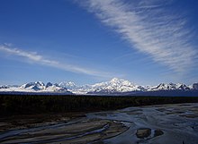
Denali State Park is a 325,240-acre (131,620 ha) state park in the U.S. state of Alaska. It is located in the Matanuska-Susitna Borough[3] adjacent to the east side of Denali National Park and Preserve, along the Parks Highway.

The park is undeveloped wilderness except for the two day-use areas, four campgrounds, and two trailheads accessible from the Parks Highway. These include:[1]
- Alaska Veterans Memorial
- Denali Viewpoint South
- K'esugi Ken Campground
- Byers Lake Campground, near Byers Lake
- Denali Viewpoint North Campground
- Lower Troublesome Creek Campground
- Upper Troublesome Creek Trail (closed in 2009 due to washouts caused by severe flooding)[4]
- Kesugi Ridge Trail
- Little Coal Creek Trail
- ^ a b "Alaska State Parks near Trapper Creek in the Susitna Valley". Division of Parks and Outdoor Recreation. Alaska. Archived from the original on December 18, 2000.
{{cite web}}: CS1 maint: unfit URL (link) - ^ "Denali National Park and Preserve - Aviation Reporting Coordinates (U.S. National Park Service)". National Park Service, Department of the Interior.
- ^ U.S. Geological Survey Geographic Names Information System: Denali State Park
- ^ Valencia, Kris (March 2009). The Milepost (61st ed.). Morris Communications Company, LLC. p. 406. ISBN 978-1892-15426-2.