This article relies largely or entirely on a single source. (December 2007) |
Denkanikottai
Thenkanikottai | |
|---|---|
Town | |
| Thenkanikottai | |
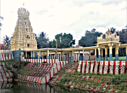
 Betrayswamy Temple, Denkanikottai | |
| Nickname: The Little England | |
| Coordinates: 12°31′36″N 77°47′34″E / 12.52667°N 77.79278°E | |
| India | |
| Tamil Nadu | |
| Region | Kongu Nadu |
| District | Krishnagiri |
| Government | |
| • Type | Town Panchayat |
| • Body | Denkanikottai Town Panchayat |
| Area | |
| • Total | 14 km2 (5 sq mi) |
| Elevation | 879 m (2,884 ft) |
| Population (2015) | |
| • Total | 31,868 |
| • Density | 1,702/km2 (4,410/sq mi) |
| Time zone | UTC+5:30 (IST) |
| PIN | 635107 |
| Telephone code | 04347 |
| Vehicle registration | TN-70 |
| Website | townpanchayat.in/denkanikottai |
Denkanikottai also known as Thenkanikottai is a Panchayat Town in Krishnagiri district in the state of Tamil Nadu, India. It is the headquarters of Denkanikottai Taluk. Its altitude 879 m (2,884 ft) elevation above the sea level. It is a multicultural town with a mix of linguistic groups. Tamil is the official and spoken language. There are a significant number of Kannada, Urdu and Telugu and speakers in the town as it is very near to Karnataka State bordering it. The place is named after the legend of Betrayaswamy Temple located in the centre of the town.

