Piura
Departamento de Piura (Spanish) | |
|---|---|
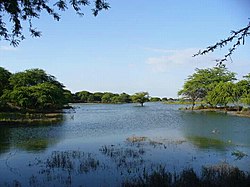
 Ñapique Lagoon | |
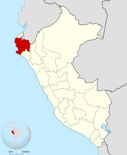
 Location of the Piura Region in Peru | |
| Coordinates: 4°59′S 80°25′W / 4.99°S 80.41°W | |
| Country | Peru |
| Subdivisions | 8 provinces and 64 districts |
| Founded by | Francisco Pizarro |
| Capital | Piura |
| Government | |
| • Governor | Servando García Correa (2019–2022) |
| Area | |
| • Total | 35,892.49 km2 (13,858.17 sq mi) |
| Elevation (Capital) | 29 m (95 ft) |
| Highest elevation | 3,023 m (9,918 ft) |
| Lowest elevation | −34 m (−112 ft) |
| Population (2022) | |
| • Total | 2,103,099 |
| • Density | 59/km2 (150/sq mi) |
| UBIGEO | 20 |
| Dialing code | 073 |
| ISO 3166 code | PE-PIU |
| Principal resources | Petroleum, rice, cotton, lemon |
| Poverty rate | 19.1% |
| Percentage of Peru's GDP | 3.94% |
| Website | www.regionpiura.gob.pe |
Piura (Spanish pronunciation: [ˈpjuɾa]) is a coastal department and region in northwestern Peru. The region's capital is Piura and its largest port cities, Paita and Talara, are also among the most important in Peru. The area is known for its tropical and dry beaches. It is the most populous department in Peru, its twelfth smallest department, and its fourth-most densely populated department, after Tumbes, La Libertad, and Lambayeque.
The country's latest decentralization program is in hiatus after the proposal to merge departments was defeated in the national referendum in October 2005.[1][failed verification] The referendum held on October 30, 2005, as part of the ongoing decentralization process in Peru, to decide whether the region would merge with the current regions of Lambayeque and Tumbes to create a new Región Norte was defeated.[citation needed]

