Depew, Oklahoma | |
|---|---|
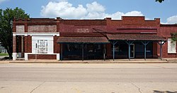
 Historic US 66 as it passes through Depew | |
 Location within Creek County, and the state of Oklahoma | |
| Coordinates: 35°48′16″N 96°31′47″W / 35.80444°N 96.52972°W | |
| Country | United States |
| State | Oklahoma |
| County | Creek |
| Area | |
| • Total | 1.02 sq mi (2.64 km2) |
| • Land | 1.02 sq mi (2.64 km2) |
| • Water | 0.00 sq mi (0.00 km2) |
| Elevation | 883 ft (269 m) |
| Population (2020) | |
| • Total | 411 |
| • Density | 403.73/sq mi (155.86/km2) |
| Time zone | UTC-6 (Central (CST)) |
| • Summer (DST) | UTC-5 (CDT) |
| ZIP Code | 74028 |
| Area code(s) | 539/918 |
| FIPS code | 40-20300[3] |
| GNIS feature ID | 2412420[2] |
Depew is a town in Creek County, Oklahoma, United States. It is 41 miles southwest of Tulsa. The population was 411 at the 2020 census.[4][circular reference] The town was named in honor of New York Senator Chauncey Depew.[5]
- ^ "ArcGIS REST Services Directory". United States Census Bureau. Retrieved September 20, 2022.
- ^ a b U.S. Geological Survey Geographic Names Information System: Depew, Oklahoma
- ^ "U.S. Census website". United States Census Bureau. Retrieved 2008-01-31.
- ^ "Depew (town), Oklahoma". United States Census Bureau. Retrieved August 13, 2023.
- ^ Wilson, Linda D. "Depew" Archived 2008-12-30 at the Wayback Machine. Encyclopedia of Oklahoma History and Culture. Retrieved March 23, 2012.