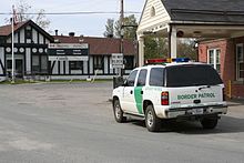
Derby Line | |
|---|---|
Village | |
 Haskell Free Library and Opera House | |
| Coordinates: 45°00′17.98″N 72°05′57.97″W / 45.0049944°N 72.0994361°W | |
| Country | |
| State | |
| County | Orleans County |
| Town | Derby |
| Organized | June 16, 1977 |
| Area | |
| • Total | 0.73 sq mi (1.89 km2) |
| • Land | 0.73 sq mi (1.88 km2) |
| • Water | 0.00 sq mi (0.01 km2) |
| Elevation | 1,056 ft (322 m) |
| Population (2020) | |
| • Total | 687 |
| • Density | 940/sq mi (360/km2) |
| Time zone | UTC-5 (EST) |
| • Summer (DST) | UTC-4 (EDT) |
| ZIP code | 05830 |
| Area code | 802 |
| FIPS code | 50-17500[2] |
| GNIS feature ID | 1457154[3] |
Derby Line is an incorporated village in the town of Derby in Orleans County, Vermont, United States, slightly north of the 45th parallel, the nominal U.S.-Canada boundary. The population was 687 at the 2020 census.[4]
The village is located on the Canada–United States border and is contiguous with the district of Rock Island in the town of Stanstead, Quebec.[5]

Notable buildings include the Haskell Free Library and Opera House.
- ^ "2019 U.S. Gazetteer Files". United States Census Bureau. Retrieved August 7, 2020.
- ^ "U.S. Census website". United States Census Bureau. Retrieved January 31, 2008.
- ^ "U.S. Board on Geographic Names". United States Geological Survey. October 25, 2007. Retrieved January 31, 2008.
- ^ "Census - Geography Profile: Derby Line village, Vermont". United States Census Bureau. Retrieved December 26, 2021.
- ^ Austen, Ian (July 18, 2007). "Quebec and Vermont Towns Bond Over a Sleepy Border". The New York Times. Archived from the original on October 4, 2011. Retrieved April 2, 2021.
{{cite news}}: CS1 maint: unfit URL (link)

