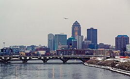
Greater Des Moines | |
|---|---|
| Des Moines–West Des Moines, IA Metropolitan Statistical Area | |
 Map of Counties in the Des Moines, Iowa metropolitan area | |
| Coordinates: 41°34′48″N 93°36′45″W / 41.58°N 93.6125°W | |
| Country | United States |
| State(s) | |
| Largest city | Des Moines |
| Other cities | - West Des Moines - Ankeny - Urbandale |
| Area | |
| • Total | 3,610 sq mi (9,300 km2) |
| Lowest elevation | 750 ft (228.6 m) |
| Population (2022) | |
| • Total | 740,363 |
| • Rank | 82nd in the U.S. |
| • Density | 196.5/sq mi (75.9/km2) |
| GDP | |
| • MSA | $67.334 billion (2022) |
The Des Moines metropolitan area, officially known as the Des Moines–West Des Moines, IA Metropolitan Statistical Area (MSA) is located at the confluence of the Des Moines River and the Raccoon River. Des Moines serves as the capital of the U.S. state of Iowa. The metro area consists of six counties in central Iowa: Polk, Dallas, Warren, Madison, Guthrie, and Jasper.[2] The Des Moines–Ames–West Des Moines Combined Statistical Area (CSA) encompasses the separate metropolitan area of Ames (Story Country), and the separate micropolitan areas of Pella (Marion County), Boone (Boone County) and Oskaloosa (Mahaska). The Des Moines area is a fast-growing metro area.[3]
- ^ "Total Gross Domestic Product for Des Moines-West Des Moines, IA (MSA)". Federal Reserve Economic Data. Federal Reserve Bank of St. Louis.
- ^ Norvell, Kim (September 21, 2018). "Feds add Jasper County to Des Moines metro stats". Des Moines Register. Retrieved December 8, 2020.
- ^ "Greater Des Moines is fastest-growing Midwest metro". Business Record. April 19, 2019. Retrieved December 8, 2020.


