| Desna | |
|---|---|
 | |
 The Dnieper and the Desna rivers' drainage basin. In this map, Belarus is shown in yellow, Russia in green and Ukraine in deep red. | |
| Native name | |
| Location | |
| Country | Russia, Ukraine |
| Cities | Bryansk, Novhorod-Siverskyi, Chernihiv |
| Physical characteristics | |
| Source | |
| • location | Smolensk Heights, Russia |
| • coordinates | 54°35′16″N 33°17′32″E / 54.58778°N 33.29222°E |
| Mouth | Desna Delta |
• location | just north of Kyiv, Ukraine |
• coordinates | 50°33′02″N 30°32′21″E / 50.55056°N 30.53917°E |
| Length | 1,130 km (700 mi) |
| Basin size | 88,900 km2 (34,300 sq mi) |
| Discharge | |
| • location | Kyiv |
| • average | 360 m3/s (13,000 cu ft/s) |
| Basin features | |
| Progression | Dnieper→ Dnieper–Bug estuary→ Black Sea |
| Tributaries | |
| • left | Seym, Oster |
| • right | Sudost |
 | |
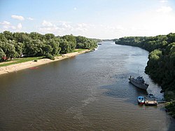
The Desna (Russian: Десна; Ukrainian: Десна) is a river in Russia and Ukraine, a major left-tributary of the Dnieper. Its name means "right hand" in the Old East Slavic language.[citation needed] It has a length of 1,130 km (702 mi), and its drainage basin covers 88,900 km2 (34,324 sq mi).[1]
In Ukraine, the river's width ranges from 60 to 250 metres (200 to 820 ft), with its average depth being 3 m (10 ft). The mean annual discharge at its mouth is 360 m3/s (13,000 cu ft/s).[1] The river freezes over from early December to early April, and is navigable from Novhorod-Siverskyi to its mouth, a length of about 535 km (332 mi).[1]
The water level of the river reached its lowest recorded point in 140 years in June 2020. This water level was 5 m (16 ft) below normal for that time of year.[2]
- ^ a b c Десна, Great Soviet Encyclopedia.
- ^ "Signs of Drought in European Groundwater". earthobservatory.nasa.gov. 2020-06-25. Retrieved 2021-04-14.