Deuel County | |
|---|---|
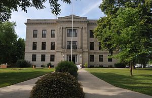
 Deuel County Courthouse | |
 Location within the U.S. state of South Dakota | |
 South Dakota's location within the U.S. | |
| Coordinates: 44°46′N 96°40′W / 44.76°N 96.67°W | |
| Country | |
| State | |
| Founded | 1862 (created) 1878 (organized) |
| Named for | Jacob Deuel |
| Seat | Clear Lake |
| Largest city | Clear Lake |
| Area | |
| • Total | 637 sq mi (1,650 km2) |
| • Land | 623 sq mi (1,610 km2) |
| • Water | 14 sq mi (40 km2) 2.2% |
| Population (2020) | |
| • Total | 4,295 |
| • Estimate (2023) | 4,354 |
| • Density | 6.7/sq mi (2.6/km2) |
| Time zone | UTC−6 (Central) |
| • Summer (DST) | UTC−5 (CDT) |
| Congressional district | At-large |
Deuel County (/ˈduːl/ DOOL)[1] is a county in the U.S. state of South Dakota. As of the 2020 census, the population was 4,295.[2] Its county seat is Clear Lake.[3] The county was created in 1862, and was organized in 1878.[4] It is named for Jacob Deuel, a legislator in 1862.[5]
- ^ "Broadcast Pronunciation Guide and South Dakota Pronunciations". Associated Press. Archived from the original on June 14, 2011. Retrieved November 10, 2009.
- ^ "State & County QuickFacts". United States Census Bureau. Retrieved March 21, 2024.
- ^ "Find a County". National Association of Counties. Archived from the original on May 31, 2011. Retrieved June 7, 2011.
- ^ "Dakota Territory, South Dakota, and North Dakota: Individual County Chronologies". Dakota Territory Atlas of Historical County Boundaries. The Newberry Library. 2006. Archived from the original on April 2, 2018. Retrieved March 29, 2015.
- ^ Gannett, Henry (1905). The Origin of Certain Place Names in the United States. Govt. Print. Off. p. 105.