This article needs additional citations for verification. (September 2020) |
Dhangadhi
धनगढी | |
|---|---|
 Behda Baba Temple | |
| Coordinates: 28°42′49″N 80°34′09″E / 28.71361°N 80.56917°E | |
| Country | |
| Province | Sudurpashchim |
| District | Kailali |
| Government | |
| • Mayor | Gopal Hamal (Independent)[1] |
| • Deputy Mayor | Kandakala Kumari Rana (UML) |
| Area | |
| • Total | 271.74 km2 (104.92 sq mi) |
| Elevation | 109 m (358 ft) |
| Population (2021)[2] | |
| • Total | 204,788 |
| • Rank | 7th largest |
| • Density | 750/km2 (2,000/sq mi) |
| Time zone | UTC+5:45 (NST) |
| Post code | 10900 |
| Area code | 091 |
| Website | www |
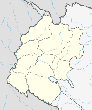
Dhangadhi (Nepali: धनगढी) is a sub-metropolitan city[3] and the district headquarters of Kailali District in Sudurpashchim Province of Nepal. It shares a border with India in the south, Godawari and Gauriganga Municipality in the North, Kailari Rural Municipality in the east and Kanchanpur District in the west. Dhangadhi is a sub-metropolis divided into 19 wards.[4] It has an area of 271.74 Sq. KM. It is one of the major cities of Far - West Province of Nepal along with Mahendranagar.[5][6] The city is connected with the Mahakali Highway, about 750 kilometers west of Kathmandu.
Dhangadhi was established in 1976 as a municipality.[7] There is a fable. Rana Tharu of Dhangadhi used to bury their wealth in the ground due to the fear of robbers. That is why the name of Dhangadhi remained Dhangadhi.[8]
198,792 population as per 2021 Nepal census. It is the most densely populated city in the province.[9] It became the first sub-metropolitan city in the far-west after it was upgraded to a sub-metropolis from municipality status on 18 September 2015 as the village development committees Fulbari and Urma were merged into Dhangadhi and later wards 9 and 11 of former Attariya Municipality were also merged.
- ^ "धनगढीका मेयर गोपाल हमालको मतले कैलाली जिससमा गठबन्धन विजयी".
- ^ "Preliminary Report of National Population 2021". Central Bureau Statistics, Nepal. 27 January 2022. Retrieved 9 March 2022.
- ^ "The Kathmandu Post :: Govt declares 26 new municipalities". Archived from the original on 22 November 2017. Retrieved 13 March 2016.
- ^ "Dhangadhi Sub-Metropolitan City". Retrieved 1 May 2018.
- ^ "Archived copy" (PDF). Archived from the original (PDF) on 18 April 2013. Retrieved 1 November 2012.
{{cite web}}: CS1 maint: archived copy as title (link) - ^ "PSU Dhangadhi | Local Governance and Community Development Programme (LGCDP) - II". lgcdp.gov.np. Archived from the original on 29 June 2019. Retrieved 29 June 2019.
- ^ "Brief Introduction". Dhangadhi Sub-Metropolitan City. Archived from the original on 13 May 2018. Retrieved 1 May 2018.
- ^ "26 new Municipalities announced". The Rising Nepal. 18 September 2015. Archived from the original on 27 September 2015. Retrieved 1 May 2018.
- ^ "population | national_population and housing_census_year results". censusnepal.cbs.gov.np. Retrieved 3 February 2024.

