This article needs additional citations for verification. (December 2023) |
Dholpur district | |
|---|---|
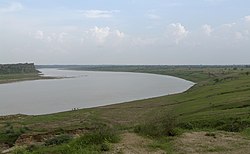
Rani ki Haveli in Machkund, Kalia Mata Temple in Bari, Talab-e-Shahi, Chambal River near Dholpur, Shergarh Fort | |
 Location of Dholpur district in Rajasthan | |
| Country | |
| State | Rajasthan |
| Division | Bharatpur |
| Area | |
| • Total | 33.3 km2 (12.9 sq mi) |
| Population (2011)[1] | |
| • Total | 1,206,516 |
| • Density | 36,000/km2 (94,000/sq mi) |
| Time zone | UTC+05:30 (IST) |
Dholpur District is a district of Rajasthan state in Northern India. The town of Dholpur is the district headquarters. Dholpur District is a part of Bharatpur Divisional Commissionerate. It was carved out from the erstwhile Bharatpur District on 15 April 1982.[2]
Dholpur District has an area of 3084 km2. The Chambal River forms the southern boundary of the district, across which lies the state of Madhya Pradesh. The district is bounded by the state of Uttar Pradesh on the east and northeast, by Bharatpur District of Rajasthan on the northwest, and Karauli District of Rajasthan on the west. All along the bank of the Chambal River the district is deeply intersected by ravines; low ranges of hills in the western portion of the district supply quarries of fine-grained and easily worked red sandstone.
Administratively the district is divided into four subdivisions, Dholpur, Bari, Rajakhera, and Baseri, and six tehsils, Dholpur, Bari, Rajakhera, Basedi, Sarmathura and Saipau.
- ^ Cite error: The named reference
districtcensuswas invoked but never defined (see the help page). - ^ "History | DISTRICT COURT DHOLPUR | India". Retrieved 25 February 2024.


