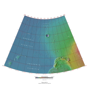
 Map of Diacria quadrangle from Mars Orbiter Laser Altimeter (MOLA) data. The highest elevations are red and the lowest are blue. | |
| Coordinates | 47°30′N 150°00′W / 47.5°N 150°W |
|---|---|
| Eponym | Diacria highlands around Marathon in Greece |

The Diacria quadrangle is one of a series of 30 quadrangle maps of Mars used by the United States Geological Survey (USGS) Astrogeology Research Program. The quadrangle is located in the northwestern portion of Mars' western hemisphere and covers 180° to 240° east longitude (120° to 180° west longitude) and 30° to 65° north latitude. The quadrangle uses a Lambert conformal conic projection at a nominal scale of 1:5,000,000 (1:5M). The Diacria quadrangle is also referred to as MC-2 (Mars Chart-2).[1] The Diacria quadrangle covers parts of Arcadia Planitia and Amazonis Planitia.
The southern and northern borders of the Diacria quadrangle are approximately 3,065 km (1,905 mi) and 1,500 km (930 mi) wide, respectively. The north to south distance is about 2,050 km (1,270 mi) (slightly less than the length of Greenland).[2] The quadrangle covers an approximate area of 4.9 million square km, or a little over 3% of Mars' surface area.[3] The Phoenix lander's landing site (68.22° N, 234.25° E) lies about 186 km (116 mi) north of the northeastern quarter of the Diacria quadrangle. The landscape viewed by the Phoenix lander is probably representative of a large portion of the terrain in the northern Diacria quadrangle.
- ^ Davies, M.E.; Batson, R.M.; Wu, S.S.C. "Geodesy and Cartography" in Kieffer, H.H.; Jakosky, B.M.; Snyder, C.W.; Matthews, M.S., Eds. Mars. University of Arizona Press: Tucson, 1992.
- ^ Distances calculated using NASA World Wind measuring tool. "NASA WorldWind".
- ^ Approximated by integrating latitudinal strips with area of R^2 (L1-L2)(cos(A)dA) from 30° to 65° latitude; where R = 3889 km, A is latitude, and angles expressed in radians. See: "Calculating area enclosed by arbitrary polygon on Earth's surface - Stack Overflow".