Diamond Heights | |
|---|---|
 Diamond Heights and Glen Canyon Park | |
| Coordinates: 37°44′45″N 122°26′30″W / 37.7457639°N 122.4416379°W | |
| Government | |
| • Supervisor | Rafael Mandelman[1] |
| • Assemblymember | Matt Haney (D)[2] |
| • State Senator | Scott Wiener (D)[2] |
| • U.S. House | Nancy Pelosi (D)[3] |
| Area | |
| • Total | 1.13 km2 (0.436 sq mi) |
| • Land | 1.13 km2 (0.436 sq mi) |
| Population | |
| • Total | 2,332 |
| • Density | 2,064/km2 (5,345/sq mi) |
| 2008 | |
| ZIP Code | 94131 |
| Area codes | 415/628 |
| [5] | |
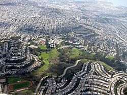
Diamond Heights is a neighborhood in central San Francisco, California, roughly bordered by Diamond Heights Boulevard and Noe Valley to the north and east and Glen Canyon Park to the south and west. It is built on three hills: Red Rock Heights on the northwest, Gold Mine Hill in center, and Fairmount Heights (including Billy Goat Hill) on the southeast.
- ^ "Mandelman ousts incumbent Sheehy in SF's District Eight". SF Chronicle. Retrieved May 26, 2020.
- ^ a b "Statewide Database". UC Regents. Retrieved December 29, 2014.
- ^ "California's 11th Congressional District - Representatives & District Map". Civic Impulse, LLC.
- ^ a b "Diamond Heights neighborhood in San Francisco, California (CA), 94131 detailed profile". Urban Mapping Inc. 2011.
- ^ "Diamond Heights, San Francisco, California Neighborhood Zip Code Map Boundary Version 1.0". John Coryat - USNaviguide. 2009.
