Dickson Township, Michigan | |
|---|---|
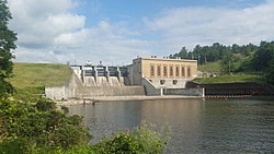
 Tippy Dam on the Manistee River | |
| Coordinates: 44°17′57″N 85°56′46″W / 44.29917°N 85.94611°W | |
| Country | |
| State | |
| County | Manistee |
| Area | |
| • Total | 71.5 sq mi (185 km2) |
| • Land | 69.5 sq mi (180 km2) |
| • Water | 2.0 sq mi (5 km2) |
| Elevation | 860 ft (262 m) |
| Population | |
| • Total | 980 |
| • Density | 14.1/sq mi (5.4/km2) |
| Time zone | UTC-5 (Eastern (EST)) |
| • Summer (DST) | UTC-4 (EDT) |
| ZIP Codes | |
| FIPS code | 26-101-22320[3] |
| GNIS feature ID | 1626185[4] |
Dickson Township is a civil township of Manistee County in the U.S. state of Michigan. The population was 980 at the 2020 census.[2]
Most of the township lies within the Manistee National Forest. The Manistee River runs through the eastern and southern portions, with the Tippy Dam forming the Tippy Dam Pond along the south-central boundary.
- ^ "2022 U.S. Gazetteer Files: Michigan". United States Census Bureau. Retrieved August 7, 2023.
- ^ a b "P1. Race – Dickson township, Michigan: 2020 DEC Redistricting Data (PL 94-171)". U.S. Census Bureau. Retrieved August 7, 2023.
- ^ "U.S. Census website". United States Census Bureau. Retrieved January 31, 2008.
- ^ U.S. Geological Survey Geographic Names Information System: Dickson Township, Michigan

