| Disputed island | |
|---|---|
 Aerial photograph of Diego Garcia | |
| Geography | |
| Coordinates | 7°18′48″S 72°24′40″E / 7.31333°S 72.41111°E |
| Archipelago | Chagos Archipelago |
| Adjacent to | Indian Ocean |
| Area | 30 km2 (12 sq mi) |
| Administration | |
| Territory | |
| Claimed by | |
| Outer Islands | Chagos Archipelago |
| Demographics | |
| Population | 4,239[1] |
| Additional information | |
| Time zone | |
| Designated | 4 July 2001 |
| Reference no. | 1077[2] |
Diego Garcia is the largest island of the Chagos Archipelago, part of the British Indian Ocean Territory (BIOT). It has been used as a joint UK–U.S. military base since the 1970s, following the expulsion of the Chagossians by the UK government. The Chagos Islands have been a British overseas territory, but in early October 2024, the UK agreed to transfer sovereignty of the islands to Mauritius, while allowing the military base to remain under a 99-year lease, pending a treaty ratification.[3]
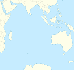
Located just south of the equator in the central Indian Ocean, Diego Garcia lies 3,535 km (2,197 mi) east of Tanzania, 2,984 km (1,854 mi) east-southeast of Somalia, 726 km (451 mi) south of the Maldives, 1,796 km (1,116 mi) southwest of India, 2,877 km (1,788 mi) west-southwest of Sumatra, 4,723 km (2,935 mi) northwest of Australia, and 2,112 km (1,312 mi) northeast of Mauritius Island. Diego Garcia is part of the Chagos-Laccadive Ridge, an underwater mountain range[4] that includes the Lakshadweep, the Maldives, and the other 60 small islands of the Chagos Archipelago. The island observes UTC+6 year-round.[5]
Diego Garcia was discovered by Portuguese sailors in 1512 and remained uninhabited until the French began using it as a leper colony and for coconut plantations in the late 18th century. After the Napoleonic Wars, the island was transferred to British control. It remained part of Mauritius until 1965, when it became part of the newly formed BIOT.
In 1966, Diego Garcia had a population of 924,[6] mostly contract workers employed in coconut plantations. However, between 1968 and 1973, the Chagossian inhabitants were forcibly removed to make way for the military base. In 2019, the International Court of Justice ruled that the UK's administration of the Chagos Archipelago was illegal, a decision supported by the United Nations, though the UK has dismissed the ruling as non-binding.
Diego Garcia remains the only inhabited island of the BIOT, with its population consisting of military personnel and contractors. It is one of two critical U.S. bomber bases in the Indo-Pacific region, alongside Andersen Air Force Base in Guam.[7] It is nicknamed the "Footprint of Freedom"[by whom?][8] due to its shape, its strategic location in the Indian Ocean, and its key role in U.S. overseas operations after the 9/11 attacks.[9]
- ^ "Country Profile: British Indian Ocean Territory (British Overseas Territory)". Foreign and Commonwealth Office. 12 April 2012. Archived from the original on 20 June 2012. Retrieved 21 June 2012.
- ^ "Diego Garcia". Ramsar Sites Information Service. Retrieved 25 April 2018.
- ^ Cite error: The named reference
Harding-2024was invoked but never defined (see the help page). - ^ World Wildlife Fund, ed. (2001). "Maldives-Lakshadweep-Chagos Archipelago tropical moist forests". WildWorld Ecoregion Profile. National Geographic Society. Archived from the original on 8 March 2010. Retrieved 21 June 2012.
- ^ "World Time Chart" (PDF). US Navy. Archived from the original (PDF) on 26 January 2012. Retrieved 7 August 2012.
- ^ Chagos Islanders v Attorney General Her Majesty's British Indian Ocean Territory Commissioner [2003] EWHC 2222 (QB) at para. 23 (9 October 2003), High Court (England and Wales)
- ^ "Chirayu Thakkar (12 Jul 2021) OVERCOMING THE DIEGO GARCIA STALEMATE". 12 July 2021.
- ^ "About".
- ^ "UK agrees to give sovereignty of the Chagos Islands to Mauritius". Al Jazeera. Retrieved 4 October 2024.
